
Route Out – Gorebridge to Newlandrig to Ford to Pathhead to West Saltoun to East Saltoun to Gifford to Garvald to Whiteadder Reservoir to Ellemford to Longformacus. For route map click here.
Route Back – Longformacus to Longyester to Longnewton to Humbie to Fala to Fala Dam to Tynehead to Middleton to Gladhouse Reservoir to Gorebridge. For route map click here.
See route on Strava.
- Weather – warm and sunny and hardly even any breeze, clouding over later in the afternoon but stayed dry all day.
- Bike type – road bike
- Distance travelled – 82.08 miles
- Riding time – 6 hours 36 minutes
- Maximum speed – 35.1 mph
- Average speed – 12.4 mph
- Height climbed – 5877 feet
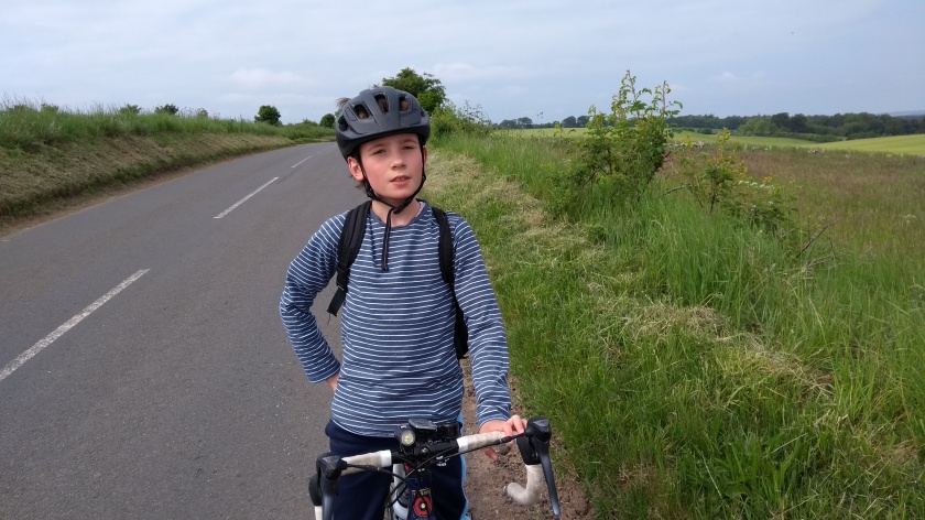
Dad and I have more or less cycled all over the Lothians and Borders the past couple of years. But one area we have never really explored properly is the Lammermuir Hills which more or less mark the boundary between East Lothian and the Scottish Borders. Well, that is at least until a few weeks ago when I decided we would embark on our longest and hilliest route so far…

After leaving Gorebridge along Vogrie Road we were soon climbing up the steep hill on the narrow road that takes you over to the Borthwick crossroads. Once you emerge from the trees the gradient eases and you also get an amaing view on your right over to the Moorfoot Hills and Fala Moor. Then, after reaching the top of the hill, the views of East Lothian, including North Berwick Law and Traprain Law came into view, as did our destination – the Lammermuirs. At the crossroads we went straight over onto the smoothest single track road in the world, speeding our way for a mile or so down to Newlandrig right next to Vogrie Country Park. There we turned right onto the B6372 and after a few yards of very bumpy road, the surface became lovely and smooth again and we had an enjoyable couple of miles of fast, slightly downhill cycling until we turned right again and down a steep hill into Ford, where we stopped for a quick photo of the

Lothian Bridge viaduct before heading up an equally steep but reasonably short hill into the village of Pathhead. Here you have to cross over the busy A68 road and you often have to wait for a long time for a suitable gap in the traffic, so take care at this point. Once across, we headed downhill on a rather bumpy road with glimpses of the viaduct to be seen through the trees on our left. At the bottom of the hill there’s a grand archway with lions on it leading into the Oxenfoord Estate but we didn’t bother going in today and stayed on the deserted country road. After going straight through another crossroads, we had a mile or so of really flat, speedy cycling and soon we went past a sign welcoming us to East Lothian. Oddly, on the other side of the sign there is no sign welcoming people travelling in the opposite direction into Midlothian. Perhaps East Lothian people are just a nicer bunch…!
At the next junction, we went right onto yet another really smooth, flat and quiet road, passing endless fields of barley and oil seed rape as we cycled past Templehall farm and skirted around Glenkinchie Distillery on our way to the lovely villages of first West Saltoun and then up a short but steep hill into East Saltoun. There we joined the B6355 road and after a few easy miles with only one short hill on a very straight road, we soon reached Gifford, zooming down the hill on brand new tarmac into the village, possibly breaking the 30 mph speed limit – who knows?! Gifford is a really nice place and we normally stop there for a snack, but recently, I have been managing to cycle for long periods without stopping and we’d only gone about 20 miles so I decided – even though Dad was feeling peckish – that we should press on… Unfortunately for my hungry companion, pressing on meant continuing on the B6355 out of the village, heading up a very steep tree-lined road for a mile or so before turning left onto the B6370, which was thankfully (for Dad!) much flatter. We started to get some closer up views of the Lammermuir Hills on the right as we cycled the 4 miles or so to the village of Garvald. Garvald is located right at the foot of the Lammermuirs and as we left the village the minor road suddenly became very steep as it took us slowly, twisting and turning through the trees. This is a very long and challenging climb into (and right over) the hills. The narrow road is at times rather bumpy but at least it is very quiet, with lots of corners and some extremely steep bits. Dad was really running low on energy by now and was
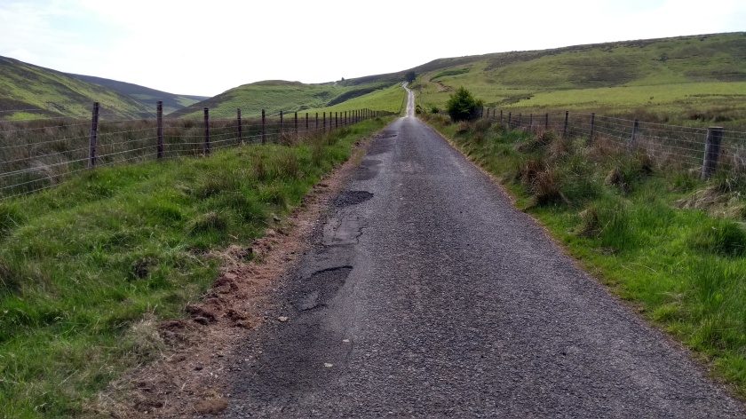
finding it hard going as I left him for dead, going as fast as I could manage until I was sure I was definitely at the top of the climb. I waited for about 5 minutes until Dad finally panted his way to the top and I allowed him to have a short rest and a bag of crisps to help him get an energy boost before the next section of the route… Along the top of the hill, the road surface suddenly improves and you get some brilliant easy downhill riding for a while on very smooth tarmac and you really get a chance to take in the views of the rounded, patchwork, heathery hills all around. Even though it’s not particularly high (about 345 m) you almost feel as though you are riding on the top of the world along

here. The road goes down and then steeply up again several times along the way and it’s quite fun to cycle with virtually no traffic to be seen. At one point, the road got unexpectedly steep straight after one of the dips into a ford (which was dry today) and we both almost got stuck in too high a gear on the way back up. Luckily neither of us fell off and eventually, after several seconds of barely travelling about 0.5 mph, we managed to get going again…

After a short while, the road descends down to meet up with the B6355 once again. Here we went left, passing by the picturesque Whiteadder Reservoir before tackling a short but steep section of road (15% according to the sign). What followed was a very pleasant, relatively flat 5 or 6 miles of cycling along the valley. It was the complete opposite of the previous 5 miles and we made good progress along what was, other than a few motor bikes, a susprisingly quiet road. After crossing an impressive old bridge, we reached the village of Ellemford where we saw a sign for Longformacus pointing right so that’s where we decided to go. This turned out to be my favourite 3 miles of the entire route. It began with another long 15% gradient climb straight up out of the village but after that it was either flat or downhill all the way to Longformacus and we didn’t see another person during that time. We got an amazing view down over the valley we’d just cycled along minutes earlier and at one point, a buzzard flew from its perch in a tree and almost crashed right into Dad’s head as he cycled along. That would have been quite a spectacular accident but thankfully the bird missed by a few inches…

Longformacus seemed like a pleasant enough place so, after 40 miles, I finally agreed to stop for lunch, much to Dad’s relief as he was about to pass out (so he said anyway…). Fuelled by Parma Ham, cheese, oatcakes and salad, we set off again, heading north-west and along a tree-lined minor road, going back uphill once more, though fairly gradually. The mostly gradually uphill theme continued for a while as we climbed back up high into the Lammermuirs. At one point we got a view across to Whiteadder Reservoir far away on the right, as well as views across to Soutra wind farm on the left. This road seemed very quiet once again (we saw 1 other cyclist and only about 2 cars in 10 miles) and it climbed up to well over 400 m. It’s quite a challenge as it has a few long, steep downhill

sections immediately followed by incredibly steep long uphills. Needless to say, Dad was struggling to keep up and I found myself having to wait for several minutes for him at the top of each of the long climbs. By the time we reached the junction with the B6355 yet again, we almost felt as though we had cycled over the Lammermuirs about 5 times in a row. When you see the Lammermuir hills from a distance they look rather low and rounded and fairly gentle. However, when you are cycling over/through them, you quickly find out that that is nothing like the truth. These hills provide some of the toughest cycling in southern Scotland.

The B6355 gave us with a very enjoyable and fast descent for a few miles – a well deserved rest almost… Rather than head all the way down the hill to Gifford again, we turned left at a crossroads and headed onto some really quiet back roads that skirt around the edge of the hills, heading vaguely westwards. These roads are quite bumpy at times but it was a pleasure to cycle on as, compared to the previous hour of so, it was mainly quite flat and easy going. We passed through tiny settlements such as Longyester and Longnewton, in and out of the trees and dodging sheep and horses at times. Before

long we came to a juntion with the B6368 where we turned left on to the slightly busier but lovely and smooth road. By now even I was starting to feel a bit peckish and in need of an energy boost. Luckily, after a mile or 2 we came to the village of Humbie where there’s a nice community run cafe/shop called the Humbie Hub. We decided to stop there and get some ice cream – a tub of strawberry for me and 2 tubs (chocolate and vanilla) for greedy Dad!

After filling our faces we continued on and soon turned right onto the B6457 for a couple of miles up the hill to Fala Village before turning right onto a minor road for a short time, speeding down the steep hill into Fala Dam and then crawling back up the even steeper hill out of the other side of the village and up to the junction with the main A68 road. Thankfully, there is actually no need to cycle in the busy traffic as there’s a path along the side of the road which we cycled on for a few hundred yards. We then waited for a gap in the traffic before crossing over onto the B6458 road. This is a quiet road with a reasonably good surface, slightly uphill at first and then flat for a few miles with the Fala Moor hill high up on your left side, before going downhill again until the village of Tynehead. Here the road goes across a bridge over the Borders Railway line before it starts to climb gradually once again for the last mile or 2 until it reaches the junction with the A7 road near its high point at Fala Hill. After such a long cycle so far, the gradual climb certainly felt a lot steeper than the road actually looks… The A7 road is quite busy at times but compared to the A68, it perfectly safe to cycle on. We turned right and sped downhill along the main road for about 2 miles, enjoying the views of the Pentland Hills in the distance. Next, we turned off onto a minor road that took us a short distance uphill to the collection of houses and farms known as Middleton.

From there, it should have been a short, downhill spin back home. But I checked our current mileage (72 miles by then!) and realised that if we managed another 10 miles or so, we’d break our distance record. Dad wasn’t too keen but reluctantly followed me as I headed along National Cycle Route no.1, skirting around the back of the Middleton quarry (lots of potholes, bumps and gravel on the road so be careful here) before turning left to head uphill towards Gladhouse Reservoir in the shadow of the Moorfoot Hills. No way would we be climbing over those hils though so we skirted around the reservoir and headed back to Gorebridge along the ups and downs of the rollercoaster ride that is the B6372. Home just in time for tea – a well deserved fish cake supper for me and a scampi supper for Dad. It had been an epic adventure: the longest, hilliest and possibly the best route I’ve ever cycled.


Great photos! I wish we had those roads here. 🙂
LikeLike
Thanks. Dad takes all the photos. Scotland is great for cycling – so many quiet roads (and lots of hills!).
LikeLiked by 1 person
I’ve started following you as a friend of mine who lives in Dunbar want to get me, from the flatlands of Newcastle upon Tyne up some of the Lammermuir climbs, I’m always looking out for new places to ride too. this is a great site and well done on your rides, you’re lucky to have such a great place to cycle around.
LikeLike