

Route – Gorebridge to Camp Wood to Southside Farm to Gorebridge. Google Maps couldn’t find the off-road part of the route so for a map, see below.
See route on Strava.
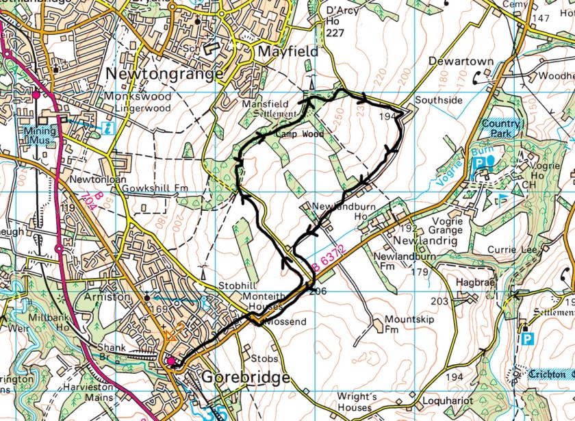
- Weather – cloudy but dry, warm enough and not much wind.
- Bike type – mountain bike
- Distance travelled – 7.66 miles
- Riding time – 50 minutes
- Maximum speed – 32.5 mph
- Average speed – 9.2 mph
- Height climbed – 640 feet
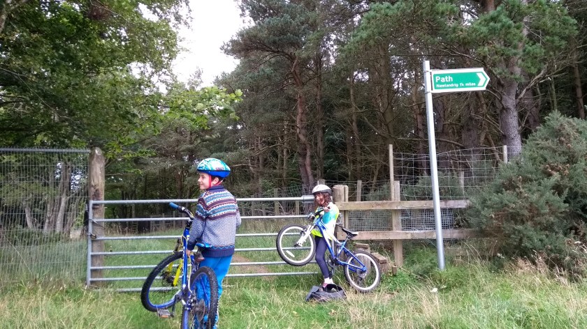
A couple of Sundays ago, Dad and I took my little sister Isla on a short but very adventurous cycle route, cycling over the hill behind our school, St Andrews Primary. Part of the route follows a path that we often walk along but this time we decided it might be fun to try it on bikes. And it actually was fun.
We headed straight up the steep hill from our house, using mostly residential streets for almost a mile until we reached the B6372 road where we headed in the direction of Vogrie Country Park. After less than half a mile, we turned left onto a quiet and narrow road with a lovely smooth surface. Soon, this road starts to go very steeply uphill (Isla had to stop and push here!) but eventually we reached the high point in the road at around 250m high. The carries on back down the other side of the hill to Mayfield but today we left tarmac behind and followed the path on the right (signposted for Edgehead) which took us into Camp Wood. The first part of the path takes you through a small farm and in the past we’ve seen all sorts of animals here including donkeys and Highland cows. Today there was only a few goats and 1 horse to be seen so that was slightly disappointing. The actual track itself is rather narrow at first but then becomes much wider after you go through a gate and enter the woods. It’s also pretty bumpy and muddy in places. However, it was relatively pleasant to cycle on.
After a short while of bumping slightly downhill through the trees, we came to a steep grassy section which was quite hard to cycle up. Dad and I managed but once again Isla had to push… At the top there is a clearing where you get amazing views across to the Moorfoot Hills in one direction and Fife, Edinburgh, Arthur’s Seat and the Pentland Hills in the other direction. Next we had to lift our bikes over a locked gate (or rather Dad did) before following the much less bumpy path through another patch of woodland for a short distance, foraging for blackberries along the way, until we emerged from the trees onto a very narrow road with a stunning view over to East Lothian in the distance. We could even see North Berwick Law and Traprain Law.

Back on road, we headed right and our next challenge was to cycle as fast as possible down the steepest and straightest section of road in Midlothian. So Dad says anyway… I once went over 40 mph down this hill but today I only managed a reasonably poor 32.5 mph. This is a very quiet road (you’ll be more likely to meet a horse than a car) but you still need to be careful as at the bottom of the hill there is a sharp bend to the left so you must slow down before you get there or you might end up going straight on into the entrance to Southside Farm (if you don’t get run down by a tractor coming round the corner the other way that is…). We slowed down safely enough but did go straight on to follow the farm road from Southside Farm for a couple of miles, most of the way back to Gorebridge. It’s quite a well surfaced road, not too bumpy and only a few potholes to avoid. You probably wouldn’t want to drive your BMW along it but I think you could manage on a road bike if you are careful.

About halfway along the road we came to a huge pile of massive tree trunks so we stopped there for a quick snack. Soon enough we came back to the narrow, smooth road we’d cycled on earlier on our way up to Camp Wood. This time we turned left and headed back to the B6372 for the last mile down the hill to our house in Gorebridge where we got home in time for an early lunch of poached eggs with smoked salmon.


