
Route out – Gorebridge to Edgehead to Cousland to Peaston. For route map click here.
Route back – Peaston to Windy Mains to Crichton to Gorebridge. For route map click here.
- Weather – sunny and not much wind. Freezing at first but much warmer after Cousland.
- Distance travelled – 24.18 miles
- Riding time – 3 hours 8 minutes
- Maximum speed – 26.5 mph
- Average speed – 7.7 mph
On Saturday morning we got up at 5:14 am and were out on our bikes before 6 o’clock. We were up so early because I was going out in the afternoon with Mum so we had to be back before lunchtime. Going cycling so early was good because the roads were very quiet and we saw lots of wildlife: deer, pheasants, squirrels and even a brown bear (more about him later on…). The bad thing about cycling in the early morning, even in mid-May on lovely sunny day, is that it was extremely cold. It will soon be summer but there was lots of frost on the ground and for the first hour of the journey, my hands were freezing! And because I was freezing, I was pedaling really slow…
As usual, the first mile from our house is straight uphill but after that, it was an easy ride along the B6372 passed Vogrie Country Park to the village of Edgehead. After another steep uphill section we stopped on the narrow road to Fordel Mains farm to look at the amazing view over to Edinburgh, The Pentland Hills, Fife and beyond. It was here that we saw the brown bear for the first time when he tried to steal my bike… About a mile from here is a place called Cousland and we stopped on a bench to have a quick snack and also to warm up our frozen fingers by clapping our hands. The cheeky bear must have followed us there and he managed to sneak onto my knee when Dad was taking a photo.
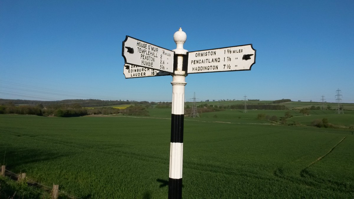
After Cousland there’s a really fast downhill section and it it was here that I reached my fastest speed of the day. Soon we came to the A6093 road at the border with East Lothian. Normally we avoid main roads but because it was very early in the day, the traffic was very light so we headed east for about half a mile and then turned right at the really amazing old road sign, heading towards Peaston. There are lots of amazing old-fashioned signs in East Lothian and I love them because they give the distances with fractions of a mile. According to this one, Peaston is 2 1/4 miles.
As it turned out, there’s not much in Peaston apart from lots of old farm building and cottages that are crumbling and falling down. Dad said it was looked like a ghost town so we didn’t even stop there. Soon we reached another favourite road sign of mine – Slow Bad Bend – next to the sawmill at Windy Mains. A mile after the sawmill we reached the ford. This is where a stream flows over the top of the road at the border of East and Mid Lothian. Here we stopped for a snack and once again, spotted the brown bear as he tried to steal one of my chocolate digestives. After I rescued my biscuit, we headed through the scenic countryside along Salters’ Road. This is a really lovely quiet road and we didn’t see any traffic until we reached the main A68 road. At one point we cycled underneath some electricity pylons and you could hear them making a crackly buzzing sound.
We crossed over the A68 and cycled down the minor road to Crichton. There’s only a few houses here and after that you come to one of the steepest hills in the world! We sped down into the gorge and then crawled back up the other side in gear 1. On the way back up, we got a good view of the ruined Crichton Castle. After a short relatively flat section we came to Borthwick crossroads where we turned right, uphill yet again, for the last mile or so back to Gorebridge.


