
Route Out – Innerleithen to Traquair to St Mary’s Loch to Megget Reservoir to Talla Reservoir to Tweedsmuir. For route map click here.
Route Back – Tweedsmuir to Stobo to Lyne Station to Pebbles to Cardona to Innerleithen. For route maps click here and here. Note that there is a bridge over the River Tweed just after Lyne Station that Google Maps doesn’t know about which is why the route back is spilt into two maps. Just follow the Borders Loop signs and you won’t get lost…
- Weather – cold and misty at first but sunny and warm for most of the day apart from one light shower in the afternoon.
- Distance travelled – 54.43 miles
- Riding time – 5 hours 27 minutes
- Maximum speed – 28.4 mph
- Average speed – 9.9 mph
On Saturday, Dad and I decided to go on another grand tour of the Scottish Borders. It was very cold when we left the house and as we drove along the road through the Moorfoot Hills the temperature dropped to 1 degrees C. It had only risen by a couple of degrees by the time we arrived in Innerleithen where we would begin the tour, so it was lucky we had brought our gloves…
We headed out of Innerleithen through the freezing mist along the B709. This is very quiet, scenic and in places narrow road, and after passing the village of Traquair, the weather brightened up and the road climbed gradually uphill for what seemed like an age through the hills. Someone has helpfully painted some funny messages on the road along the way. Just as the steepest section begins it says “and up”, and just when you think you’ve had enough it tells you it is “a wee bit further”. Eventually the good news arrived at the top of the climb with the message “and down” along with a smilie face. From there, there was a few fast and fun miles of downhill cycling until the junction with the A708. Here we turned right onto the main road which seemed quite quiet for an “A” road. After a few miles of fairly flat road, we came to the head of St Mary’s Loch. There was a thick fog hanging around over the loch and the water was so still that it was almost like a mirror. The reflection of the hills on the water surface was amazing.
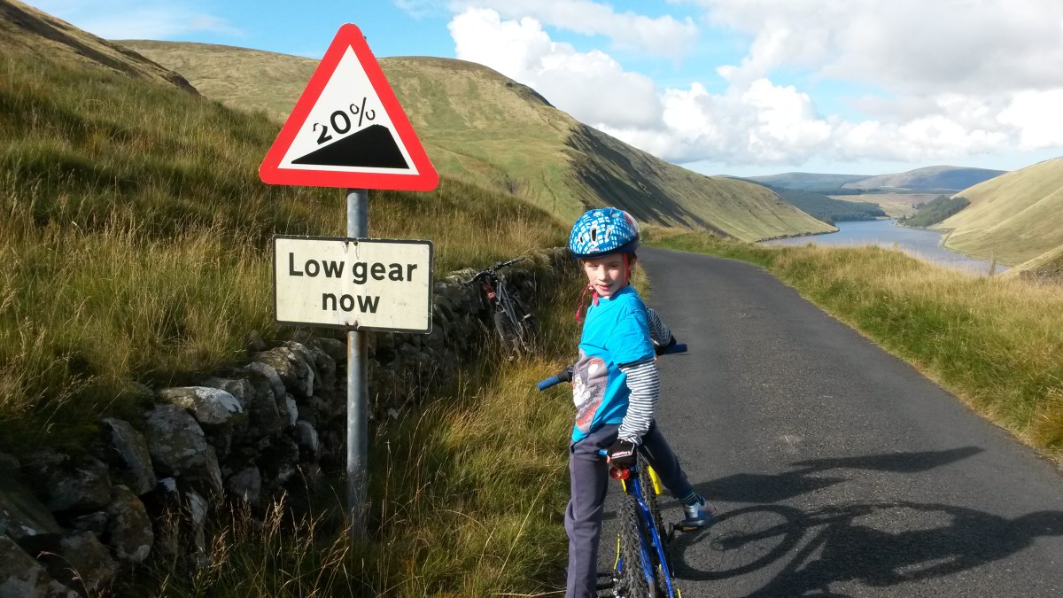
Leaving the loch behind, we turned right onto the single track road to Tweedsmuir. Dad had driven along this road before and warned me that it would be very hilly in places – and he was right. It was a really fun road to cycle on though and one of the most scenic too as it goes right through some of the highest of the Border hills. This section was virtually traffic free (apart from a police car and a quad bike) but at one point we were almost driven off the road by a flock of sheep. One of the steepest climbs takes you past Megget Reservoir. We stopped here for a chocolate digestive or 2 (well I had 1 and Dad had 2) and we were overtaken by a large group of cyclists who seemed to be taking part in some sort of race. They were going much faster than us certainly. Apparently this reservoir provides drinking water to the city of Edinburgh (at least that’s what the information sign said). The road follows the reservoir for a few miles going up and down all the time. Eventually, after passing by 2 half eaten hedgehogs and a guilty looking buzzard, we stopped at the far end of the reservoir and for an early lunch. The road then went steeply uphill for a while until, finally, we reached the highest point of the road at about 450m high according to the map. From there the view down through the hills to the Talla reservoir was stunning and the road down to it was incredibly steep – the sign said it was a 20% gradient so I was glad were going down and not up this hill. Strangely, the group of cyclists we saw earlier were racing back up this steep hill as fast as they could. It must have been torture. We left them to it and sped the other way as slowly as possible (15mph with brakes fully on!) in order to avoid crashing and were soon cycling on the flat road alongside the Talla reservoir with impressive mountains on both sides. At the far end of the reservoir we saw a deer jump in and start swimming for the other side. Dad said he didn’t know deer could swim. Maybe they can’t. Hopefully it made it across OK… Then it was only a short downhill stretch to the village of Tweedsmuir where we had a rest (and another digestive) before tackling the next section of the grand tour.
We turned right after Tweedsmuir onto the main A701 road. This is a very scenic road to cycle on. The only problem is that it’s a main road, and although it’s the signposted “Borders Loop” cycle route and is not too busy for an “A” road, it seems to be popular with motor bikes too and we got over-taken loads of times, making it not too pleasant really. Because of all the hills everywhere, there are no other possible roads to take so we had no option but to go this way or back up over the 20% climb … so the A701 won. Annoyingly, there’s a dismantled railway line which basically follows the road all the way. If only someone would turn this into a cycle path, then we could have avoided the main road altogether… Anyway, after about 7 miles we were glad to turn off onto the B712 which is one of the back road to Peebles. To make the route more interesting we soon detoured left off this road onto a single track road which climbed high up and gave great views of the countryside and the hills of the Tweed valley. It was along this road, after 34 miles of cycling, that we finally found our first brambles of the day. So we stopped to stuff our faces of course. Then, after a fast downhill section, we rejoined the B712 and cycled past Stobo Castle. Strangely enough, the B712 was even busier with traffic than the A701 and was not much fun at all despite the good views. It was quite a relief to turn off onto the narrow road for Lyne Station.
There used to be a railway station at Lyne Station back when there were steam trains running, and here we followed the Borders Loop signs again and went under the bridge of the dismantled railway line (which is a signposted walk to Peebles), then over a narrow bridge across the River Tweed (the one Google Maps doesn’t know about). After a short muddy, bumpy section through the trees, we ended up back on single track road again with lots of ups and downs for the next few miles. When we came to an amazing signpost with about a million signs on it, we followed the one for Peebles. This took us on a long cut right around the side of a hill and seems to take you in completely the wrong direction for a good while. Then there’s a lovely flat, straight section for the last mile or so into the town of Peebles.
In Peebles, we crossed a pedestrian bridge over the Tweed just off the B7062 road and then cycled through the rugby and football pitches until we came to the A72 road. Here we spotted the signpost for the Peebles to Innerleithen railway path so we followed this lovely cycle route for the 5 miles back to the car. The railway path follows the river, goes right through the middle of Cardrona golf course and you get lots of good views along the way. It’s an ideal cycle path for young cyclists as it’s very flat and other than a very short section through a quiet housing estate, it’s all off road – highly recommended. Anyway, it was a long but an brilliant day out. If you don’t mind all the steep uphill sections (we climbed over 2500 feet today), the Borders is the best place in the world for cycling. I’m already planning for the Grand Tour of the Scottish Borders vol.3…


2 thoughts on “Grand Tour of the Scottish Borders vol.2”