
Route out – Gorebridge to Eddleston to Stobo to Drumelzier to Tweedsmuir to Cappercleuch to Yarrow Feus to Yarrow to Yarrowford to Selkirk to Galashiels to Tweedbank. For route map click here.
Route back – Scotrail train from Tweedbank to Gorebridge.
See route on Strava.
- Weather – Heavy rain (and some hail) for the first 15 miles, then mainly cloudy but dry with some glimpses of sun. Quite cold and annoyingly windy (and we were cycling straight into the wind) for the last 30 miles.
- Bike type – road bike
- Distance travelled – 69.3 miles
- Riding time – 5 hours 37 minutes
- Maximum speed – 30.2 mph
- Average speed – 12.4 mph
- Height climbed – 3359 feet
Dad recently bought me a brilliant book called “Cycling Climbs of Scotland: a Road Cyclists Guide” by Simon Warren which details some of the best, and hardest hills you can possibly cycle up. One of the toughest climbs described in the book is known as the Wall of Talla. It has a 20% gradient according to the road sign and looked impossibly steep when we drove up it in the car a few weeks ago. We once cycled down it and I remember it being rather scary and very hard to stop yourself going too fast or even crashing. However, I like a challenge so was determined that this time we would climb up the “wall”. And just to make things more difficult, the route I had in mind would be one of the longest we’d ever attempted, with almost 40 miles to cycle before the 20% sign even came into view…
The weather didn’t look too promising when we left the house but the forecast said it was supposed to brighten up with just one or two showers later in the day. Well, my advice to you is never trust the weather forecast as just after leaving Gorebridge along the B6372, the rain really started coming down, interspersed with occasional bursts of hail. It really was foul and horrible to cycle in. Thank goodness we have decent lights because it was almost dark. It basically rained constantly for the first 20 miles of this route – “Showers my ar5e!” said Dad – but we decided we may as well keep plodding on, turning off the B road after a few miles and onto the minor road that skirts around the edge of Gladhouse Reservoir and then past Portmore Loch. The minor road is a lovely smooth road surface, perfect for cycling on – at least until you reach the signpost welcoming you to the Scottish Borders. After that it’s much rougher and full of potholes. Amazingly though, the awful section of potholes we spotted on our last route had been patched up. They didn’t do a very good job though as the filled in holes are almost a rough and bumpy as the potholes were! Just after Portmore, the road took us down a steep, twisting slope until the A703 road where we stopped for a drink before venturing out into the traffic…

It’s never particularly pleasant when you are cycling on a busy road and being overtaken all the time, but it’s even worse when it’s wet. We survived the 2 or 3 miles on the main road though and were soon in Eddleston where we turned right onto the minor road signposted for Lyne Station via Meldons. We were absolutely drenched by then, especially our gloves, and our hands were quite cold. We decided it would be a good idea to take off our gloves before carrying on. Bad idea. As we cycled up the gradual slope into the Meldon Hills the rain got even heavier and our hands just got even colder. So the wet gloves went back on soon enough! The Meldons road is one of the nicest you’ll ever cycle on – at least it is when the weather is decent. Today was just horrible as the road was extremely wet, flooded and muddy at times. Even on the downhills we had to go slow to avoid being constantly splashed by the water. At this stage we were so fed up that we were seriously considering aborting the planned route and just heading home. Thankfully, just as we reached the other side of the Meldons and we neared the junction with the A72, the rain suddenly stopped and skies brightened remarkably. In fact, it was almost sunny and just like that, despite the wet shoes and gloves, we both brightened up too…
After only a few metres on the A72 we turned left onto the B712. This section of the route is highly recommended, taking you into the Tweed Valley past Stobo Castle and Dawyck Botanic Garden, and is one of my favourite roads for cycling. It is mostly flat and has great views of the hills and the River Tweed (which it basically follows for about 8 miles). The road is relatively quiet and is very straight for long stretches too so it’s easy to go at a good speed. As we cycled along we were also amazed at the miles and miles of daffodils lining the road. Someone must have taken years to plant them all. Or maybe they are wild daffodils – who knows? Very beautiful anyway.

Eventually, we came to a junction with another main road, the A701. There is no way to avoid this one so we turned left and headed south. As it turned out the A701 is not very busy with traffic at all and it is also fairly flat with a reasonable surface for cycling on (well apart from the odd pothole to avoid). Like the B712, the scenery is stunning, with lovely hills all around and grand views of the River Tweed all along the 7 miles. Also, look out for several impressive-looking metal bridges crossing the river to farms and other private properties along the way. In this direction, we were heading in the opposite direction to the river flows so it should have felt as if we were cycling uphill. It felt more like we were going downhill though and in no time at all we’d arrived at the tiny hamlet of Tweedsmuir where we turned left onto the minor road and stopped at a nice old bridge and sat on some rocks at the river side and had our first proper rest of the day (after 35 miles unbelievably!). We were feeling rather peckish so ate some lunch of Parma Ham, oatcakes, grapes and celery sticks to give us an energy boost before tackling the big challenge ahead.

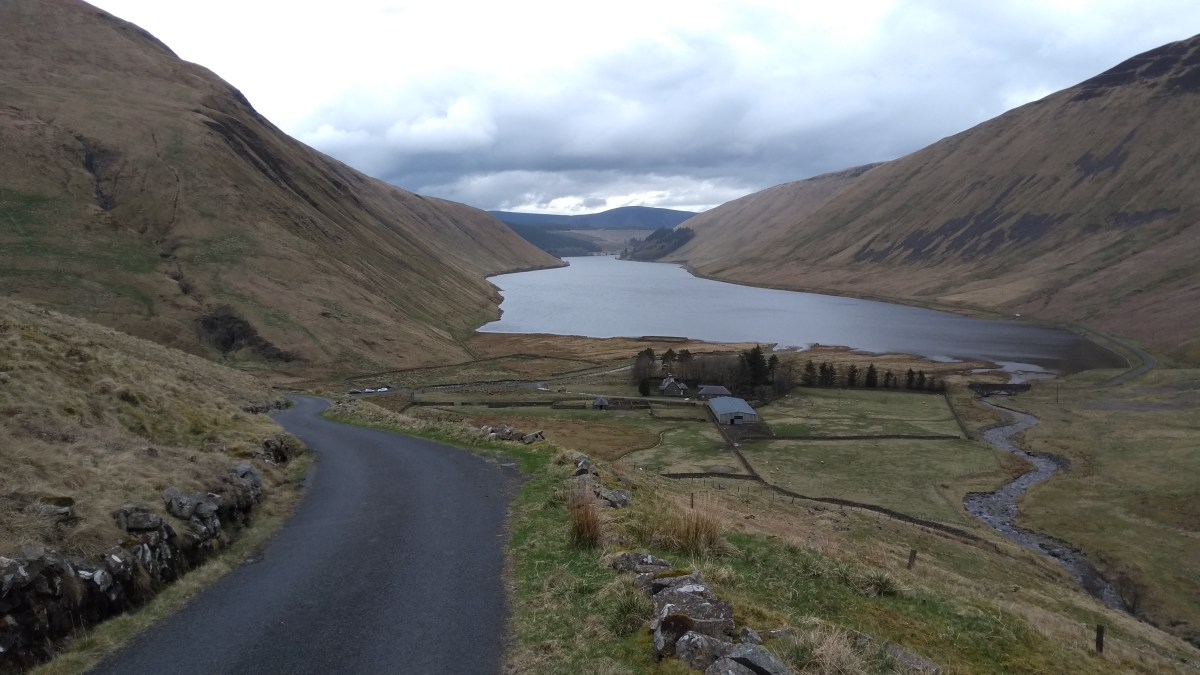
After lunch, the narrow road took us eastwards, gradually uphill and straight into an annoyingly strong and cold wind. Soon we came to the Talla Reservoir which looks rather impressive with the very steep sloped hills around it. We couldn’t see the “wall” just yet but after a flat mile or so along the water side, we rounded the end of the reservoir and then, if you looked closely, you could just make out the line of the road heading up the next hill at a stupidly steep angle. Well, there was no going back so we tried to ignore the 20% gradient sign and started up the hill in our lowest gear. Immediately we realised that this was by far the steepest and hardest hill we’d ever tried to cycle up. It was real struggle to even keep moving. Dad decided to zig-zag up the road to help cut down the gradient and this certainly helped. Thankfully, despite this being one of the quietest roads in Scotland, a few cars came along when we were going up so we had no choice but to stop and let them past. These rest breaks certainly helped (and allowed us to enjoy the view behind us back down to the reservoir below too) and we eventually managed to reach the top. We probably could have walked up the hill quicker but we had climbed 150m in a mile according to the book so we were just pleased we’d managed it without any pushing at all.

From the high point in the road you a get a great view through the hills towards the next reservoir, Megget Reservoir. We stopped at the top for a rather long rest before soldiering on into the cold wind. At least most of the next few miles was downhill with only some short ups and it really is a lovely road for cycling on – although I didn’t think so at the time as my legs were well and truly broken after climbing the wall… The area around Megget Reservoir is totally stunning and well worth stopping for a picnic on a good day. Today, we just sped past and free-wheeled down the long gradual hill for a few miles until we came to the junction with the A708 next to St Mary’s Loch.

I was feeling worn out and wasn’t looking forward to the final 25 miles or so. It would be mainly on the main road and in to the freezing wind but after re-fueling on a banana we turned left and headed for Selkirk along the A708. Thankfully, apart from a number of motor bikes, this is a fairly quiet road and as it follows the Yarrow Water, it is reasonably flat. After Talla, I was really glad of this fact but I still didn’t really enjoy this section much, despite the nice views along the valley because I was so tired. I was glad when we eventually made it to the town of Selkirk as I knew that meant there wasn’t far to go… In Selkirk we avoided climbing the steep hill into the town centre but instead took a back street that follows the river past a recycling centre and eventually takes you to the main A7 road on the outskirts of town. Here we were able to avoid the traffic by going on the shared use cycle path. After a mile or so we turned left at the cycle route signs, over a bridge across the Ettrick Water and then into the Sunderland Hall Estate. A short, flat
straight section of road then took us to another bridge over the River Tweed and then onto Cycle Route no.1. We followed the cycle route for the last few miles and it was really one of the nicest parts of the day, with a mixture of well-surfaced paths and quiet roads following the river. There was wild garlic everywhere and we got a great view of Abbotsford House across the water. Soon enough we arrived at Tweedbank Station, perfectly timed, just as the train from Edinburgh arrived. We’d had a rather challenging day and one I’ll never forget and if you feel like a bit of an adventure, I’d highly recommend to try and cycle up the Wall of Talla. You won’t regret it – even if your legs will at the time!


so it’s waterproof gloves for your birthday Rowan??
LikeLike