
Route out – Edinburgh (South Lauder Road to The Meadows to Slateford to Juniper Green) to Balerno to Kirknewton to East Calder to Broxburn. For route map click here.
Route back – Broxburn to South Queensferry to Forth Road Bridge to Dalmeny to Edinburgh (Cramond to Silverknowes to Haymarket to The Meadows to South Lauder Road). For route maps click here and here.
- Weather – mostly cloudy, not much wind and not too cold.
- Distance travelled – 43.82 miles
- Riding time – 4 hours 45 minutes
- Maximum speed – 32.9 mph
- Average speed – 9.2 mph
Just before Christmas, on the way back from Bathgate, Dad and I had intended to cycle along the Water of Leith walkway from Balerno to Slateford in Edinburgh. Unfortunately, we had run out of daylight so it had been too dark to follow this cycle path. However, we decided we’d like to go back and try that route again so we included it in a much longer circular route last weekend.
We started off in Edinburgh, following the same route as our Bathgate trip, through the Grange, The Meadows and then onto the Union Canal path (Cycle Route 754) for a few miles. After crossing over the impressive Slateford Aquaduct we turned off onto Cycle Route 75 – the Water of Leith Walkway. The path used to be a railway line and is mainly quite flat but we both found it quite hard going at times due to the wet, squelchy surface. I suspect it would be probably be a nicer path to walk on than cycle on and it would be better to go back in the summer time when it is less muddy. Along the way you get some good views of the river and some waterfalls though. One other really interesting thing about this path is that there is a time warp a few miles from Balerno. Really! I noticed at one point that we passed a sign saying “Balerno 3.5 miles” but a few minutes later we passed another sign and it was still 3.5 miles. A bit further along we reached yet another signpost which told us it was STILL 3.5 miles to Balerno. I couldn’t believe it. Soon enough, though, the next sign said it was only 3 miles to go – thank goodness. But just around the corner, the next sign once again announced: “Balerno 3.5 miles”. How could that be possible?! We really were stuck in a time warp. We had cycled about 2 miles and gone nowhere! Luckily, once we reached Currie, things returned to normal and we soon arrived in Balerno where we stopped for some crisps and carrot sticks to give us energy for the next section of the route.
After what had seemed like ages plodding along on the squelchy paths, we were both glad to be back on proper roads again for the next section of the route. We cycled a short distance along the main A70 road through Balerno before following the Route 75 sign onto an extremely steep, minor road which took us quickly downhill out into the countryside. At the bottom of the hill we turned left onto another quiet road for about 6 miles to Kirknewton and we had some nice views of the Pentland Hills and the railway line (we saw 2 trains too). At Kirknewton, we stopped for a quick look at the train station before riding over the level crossing on the rather busy B7031 road which took us to the main A71 road. Here we used the pedestrian crossing to cross over and then took a muddy track into the village of East Calder. East Calder seems like a nice enough place but we didn’t stop there and instead turned off through an archway into Almondell Country Park. The path here is much nicer for cycling on and it’s a lovely place to visit with nice views of the river Almond. We left Route 75 here and, at a bridge over the river, followed the sign post for the Union Canal. After a short time, the path takes you to a quiet narrow road and it was here that Dad spotted a buzzard sitting in a tree quite close by and at one point we got a great view of a massive viaduct in the distance. Soon, we reached the canal path once more and we had a bumpy ride for the last couple of miles to Broxburn.
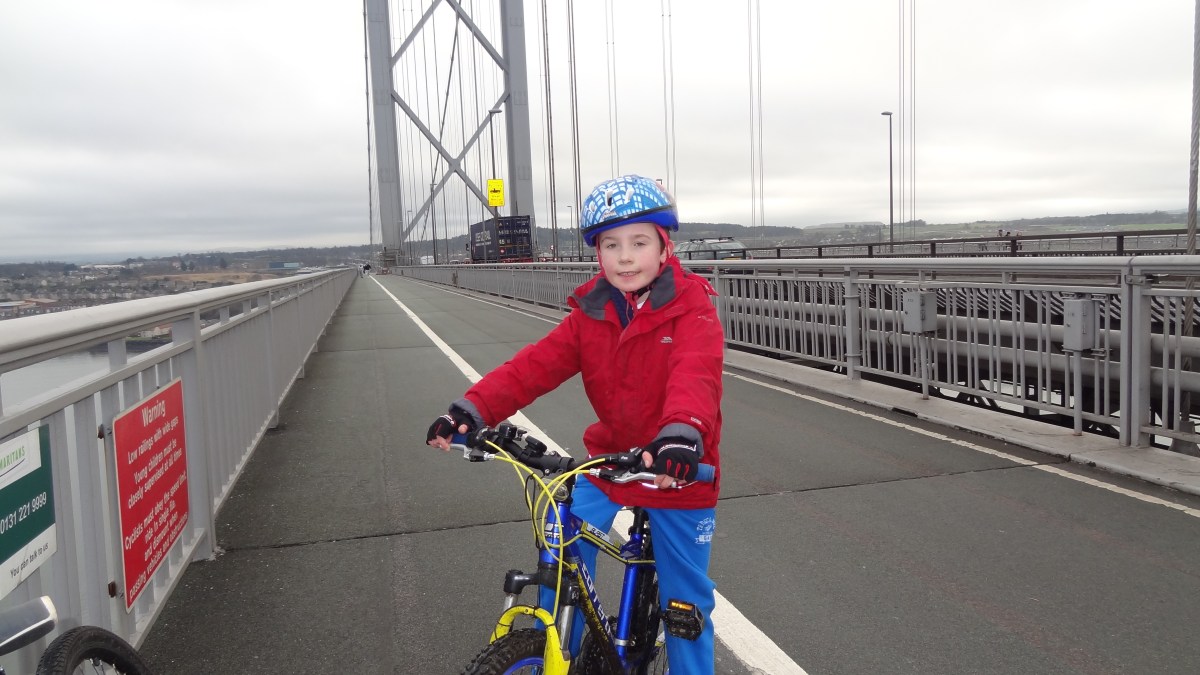
At Broxburn, the canal path surface thankfully becomes lovely and smooth and we enjoyed this section as it takes you alongside some impressive-looking bings. After a quick lunch break (cheese sandwiches and more carrot sticks), we continued along the path until a mile or so before Winchburgh, we hopped off onto yet another very quiet narrow road. According to the map, this road marks the border between West Lothian and Edinburgh City and it goes past Niddry Castle, then underneath the M9 motorway before reaching the B9080. We turned left onto this road. It is the widest road ever – wide enough for a dual carriageway but it only has 2 lanes – and after only a few hundred yards, we turned right onto another unclassified road which would take us up the hill towards Queensferry. This is a lovely quiet road and you get some unusual views of the 3 Forth Bridges once you reach the top of the hill. Eventually, the road joins onto the A904 but you don’t need to cycle on it – just follow the blue cycle route signs to Queensferry and you’ll be safe enough. Since we had plenty time, we decided to cycle over the Forth Road Bridge and then back again (stopping only to finish off the last of the carrot sticks on the Fife side of the bridge). I love cycling over the bridge as you get a great view of the railway bridge and all the trains. Dad and I both “accidentally” broke the 15 mph speed limit on the downhill parts. Oops.
On the way back from South Queensferry, we just followed Cycle Route 1 all the way back to The Meadows in Edinburgh. We’ve written about this route before (in the other direction) the last time we cycled to the Forth Bridge so for more detail, have a read of that blog. Basically, the route is mainly on a really nice cycle path and quiet residential streets apart from a short section through the city centre (though there are cycle lanes to keep you safe from the traffic here). From the Meadows, it was just a short distance back to the car. Unlike our last cycle ride, we made it back to the car with an hour of daylight left and we were home in time for tea: vegetable quiche – my favourite – with no carrot sticks…


