Bathgate to Glasgow (via the Falkirk Wheel)

Route out – Bathgate to Linlithgow to Falkirk Wheel to Kirkintilloch to Bishopbriggs to Glasgow. For route map click here.

Route back – Glasgow to Uddingston to Coatbridge to Airdie to Plains to Caldercruix to Blackridge to Bathgate. For route map click here.

See route on Strava.

  • Weather – dull at first then much brighter but with 1 horrible heavy shower around midday. Mainly sunny and warm later in the afternoon.
  • Bike type – road bike
  • Distance travelled – 80.62 miles
  • Riding time – 6 hours 42 minutes
  • Maximum speed – 32.6 mph
  • Average speed – 11.9 mph
  • Height climbed – 1958 feet

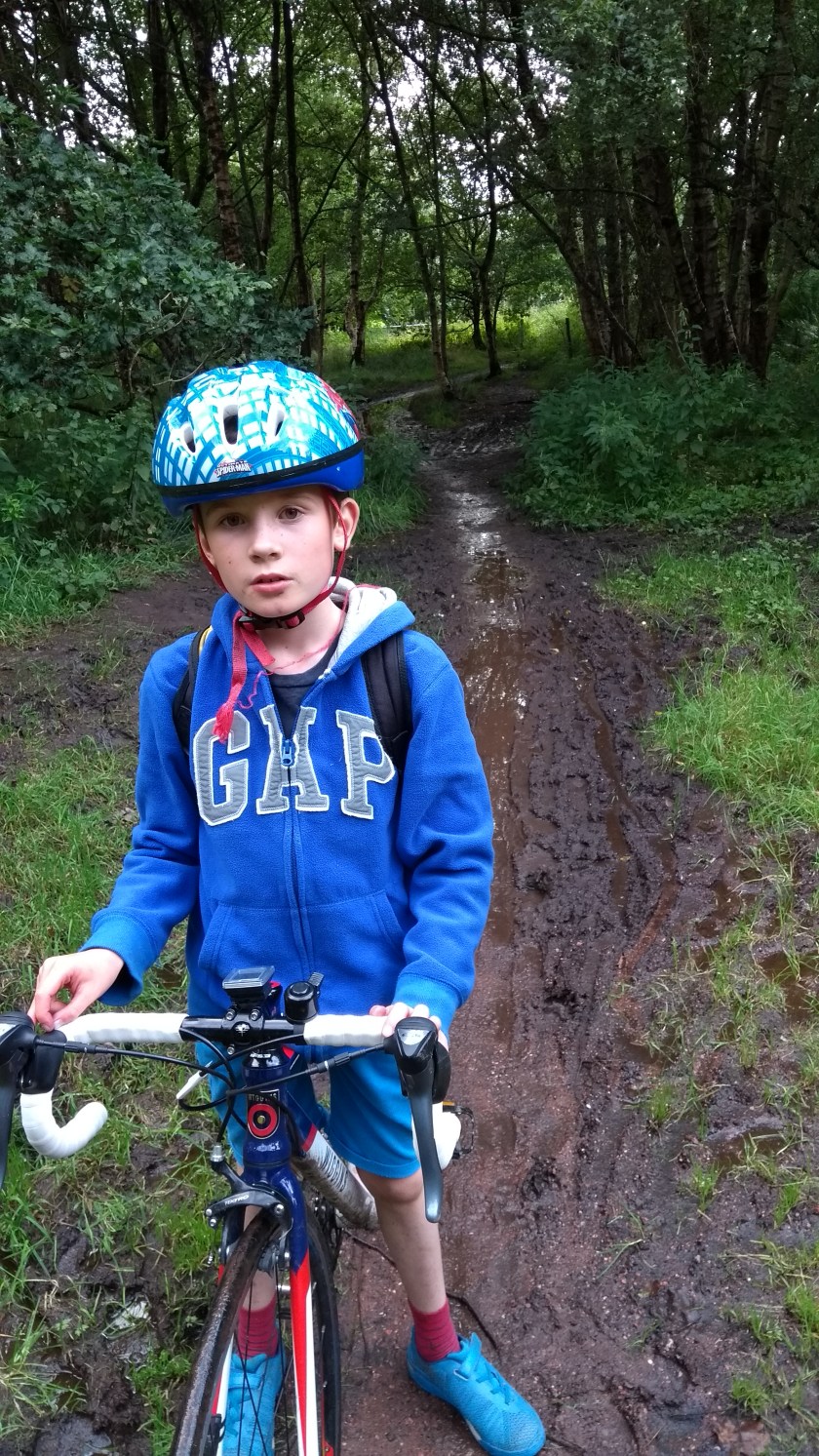
It seems like Dad and I have cycled everywhere in the south of Scotland. But last Saturday I woke up and suddenly realised that we’ve never been to the largest city in Scotland – Glagow. So I decided at 6:30am that morning that that was where we’d be cycling to that day. Unfortunately, to get to Glasgow and back from Gorebridge in a day would be basically impossible so we loaded up the car and travelled to the West Lothian town of Bathgate and by about 9:15am we were on our bikes…

We left the car on Kirkton Avenue in Bathgate and started by cycling straight up a really steep and long hill (14% gradient according to the sign) heading north for Linlithgow. It didn’t actually seem that hard a climb and soon we were out into the countryside going up and down (mostly up) for a while until we reached the top of the narrow road near Cairnpapple Hill where, despite the grey and overcast sky, we got a fine view across to the 3 bridges crossing the Firth of Forth away in the distance. From there, it was mainly downhill all the way for the few miles to Linlithgow on a relatively busy “C” class road which passes by Beecraigs Country Park on the way. The is road has a lovely smooth surface but has lots of very sharp bends on the steepest downhill sections so be careful…

IMG_20170826_094507335_BURST001

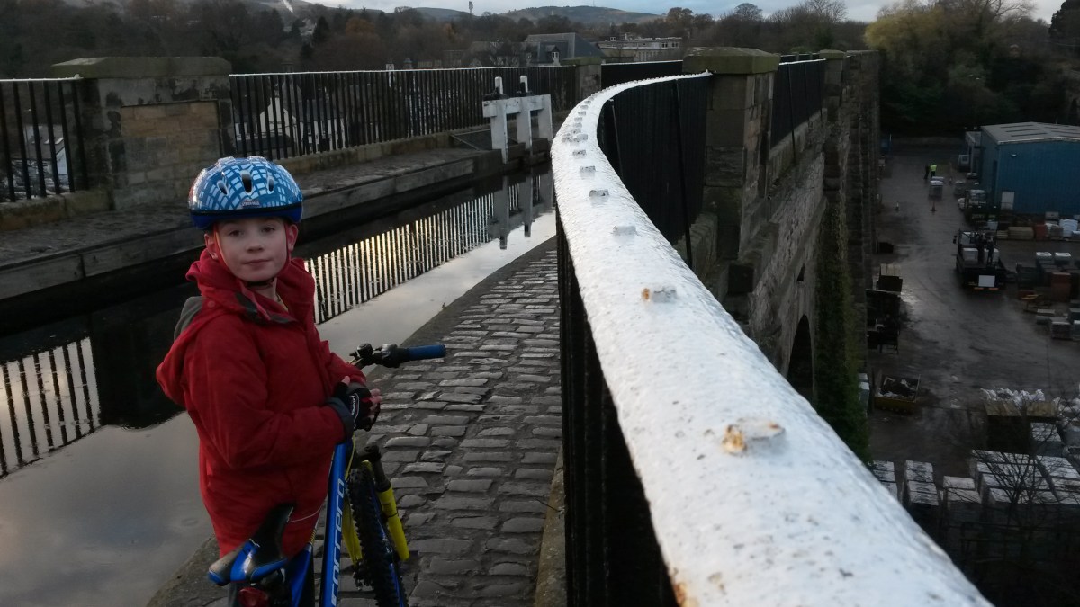
Not far into the town of Linlithgow, we turned left off the main road onto the Union Canal, cycle route 754. We’ve cycled on the canal before from Edinburgh to Linlithgow but had never gone further until today. The surface of the path was much better than I remembered, fairly smooth and with a hard-packed covering of fine stone chips, so it was perfectly OK for the road bikes. The gradient is totally flat so you have to keep pedaling pretty much constantly so it is a bit of a slog at times. You have to pass beneath many bridges and the turns here are very tight and bumpy so you have to slow to a crawl at times. You’ll also find that the path is used by millions of dog walkers (we even passed someone skiing on rollerblades!) so you have to pay attention and slow down a lot – we didn’t notice much in the way of dog dirt on the path though amazingly! Don’t expect many good views from the path either because you are always low down. The exception to this is when you cross the Avon Aqueduct (you have to push along here in case you fall in…) which gives you a stunning view down into the Avon Gorge.

IMG_20170826_100751805

Before too long, we had reached the Falkirk Tunnel. I normally like tunnels but this one was very dark, bumpy and wet, with water leaking down from above in many places. It was too dangerous to cycle through it so we pushed our bikes for what seemed like about a mile in the darkness. It wasn’t much fun and really ruined our average speed. Thankfully, we made it safely to the other side and were greeted by a much more pleasant sight – the Falkirk Wheel. It is a rather clever mechanical contraption which joins onto the end of the Union Canal and lowers a barge down into the Forth and Clyde Canal about 50m below and at the same time raises a barge up into the Union Canal. We stopped here for an early lunch of boiled eggs, Parma Ham, cheese and oatcakes whilst we watched the barges move slowly from one canal to the other. Luckily, we didn’t require the assistance of the Falkirk Wheel to reach the Forth and Clyde Canal – we just freewheeled down the hill and turned left onto our second canal path of the day.

IMG_20170826_110702724

Compared to the Union Canal, the Forth and Clyde Canal seemed much more “open” and you get much better views all along the way, especially of the Hills on the right hand side. The path surface is similarly decent, though perhaps a bit more gravelly in places. We saw fewer pedestrians and dogs on this path but many more cyclists, most heading the opposite way than us. Perhaps they were escaping Glasgow…? Interestingly, unlike the Union Canal, you don’t pass under many bridges on this canal, you tend to have to cycle up the slope until you meet the road and then cross over and down to the canal path again. This was quite annoying as there never seemed to be any pedestrian crossings and most of the roads were busy and hard to get across. On the plus side, there were loads of brambles growing along the canal-side so we managed to stop and fill our faces a couple of times. By about 1:30pm Dad spotted some high-rise flats on the other side of the water so he said we must be nearly there. Sure enough, it wasn’t long before we came upon a signpost pointing to Firhill Stadium 1 mile away. This is Partick Thistle’s football stadium and funnily enough Dad’s favourite team Aberdeen (OK, I quite like them too) was playing there today with a 3pm kick off. We could have stopped for a few hours to watch the game but we’d never have had enough time to cycle back to Bathgate in daylight so we cycled on. Luckily, the path took us right around the edge of the stadium and we were able to sneak a photo of the Aberdeen FC team bus. We also made note of the fact that because Firhill only has 3 stands, you get a great view of around 90% of the pitch if you are standing on the cycle path. That bit of knowledge will save you £25 next time your team are playing Partick Thistle…

IMG_20170826_140343169

From Firhill it was a short ride along the riverside path, down a steep hill, under the M8 motorway and then right into Glasgow city centre at Cowcaddens. We thought it would be sensible to push our bikes along the pavement in the city centre but as it turned out, pushing along the crowded pedestrianised Sauchiehall Street was the worst (and slowest) thing in the world. So we decided it would be best to brave the bus lanes and one way streets, cycling around George Square and then south towards the River Clyde. It was actually easy enough, and relatively safe, and soon we were on the pavement again, heading east along the river side path of Cycle Route no.75.

Route 75 starts off as a lovely path (watch out for dogs and children though) which follows the River Clyde for quite a long way, passing Glasgow Green and at one point giving us a glimpse of another football stadium, Celtic Park. Although the path has a mainly good surface, there are places where tree roots are growing close to the surface and this makes lots of mini speed bumps which are annoying (for Dad) or fun (for me) to cycle over. Near the outskirts of Glasgow we found a ginormous patch of brambles so stopped for quite a while to fill up. The outskirts of Glasgow basically never end as the city joins on to the fairly grim-looking towns of North Lanarkshire and around these parts there was a lot of broken glass on the path to try and avoid. At one point between Uddingston and Coatbridge, the cycle route directs you to go along a very narrow, muddy path that’s overgrown with nettles – not fun at all, especially on road bikes.

IMG_20170826_161719325

There’s also quite a number of sections where cycle route no.75 makes you go on the pavement alongside some busy main roads – this does not make for a fun cycling experience. You keep having to stop and start again, cross over roads at junctions and traffic lights so it’s hard to go a decent speed. We would have been better just going on the road and braving the traffic. It also seems to take a rather long and winding route. I reckon there must be a more direct and/or pleasant route that takes you through the country roads instead of the town so I will need to check the map later. Anyway, when we reached Airdrie, the route took us right past our 3rd football stadium of the day, the Excelsior Stadium, home of Airdie FC, so that was quite nice. After Airdrie we came to another rather grim place called Plains, where again route no.75 suggest cycling on the pavement alongside the main A89 road. At one point, we had no choice but to divert onto the road as a McGills bus had crashed into car at a junction and was blocking the way. We found the road to be much nicer to cycle on so we stayed on it for a short distance until the cycle route sign pointed to the left and we left the grim towns behind…

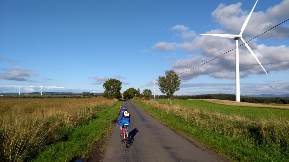
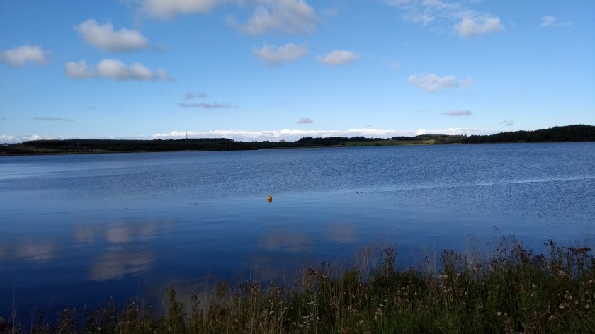
The 12 mile section of cycle route 75 from just outside Plains all the way to Bathgate is one of the nicest cycling paths ever. If you ignore the brief visits to Caldercruix and Blackridge, this section is almost all on a very quiet path with an amazingly smooth surface which makes you speed along nicely, especially on the long, slightly downhill sections. The views of the countryside are remarkably good too, including the beautiful Hillend Loch which the path skirts right around the edge of. You also get some very close up views of a wind farm which Dad and I both liked. The path follows the same route as the railway line as well, so we were lucky enough to spot about 10 trains before we made it back to Bathgate…

IMG_20170826_173630083

By the time we reached Bathgate it was about 6:30pm and we were both starving. Luckily, even though he doesn’t know the town at all, Dad has a strange homing instinct and somehow managed to direct us straight to a Dominoes Pizza. So we stopped there for tea, eating outside in the sun before cycling back to the car. It was our longest cycle route so far, our first ride over 80 miles, but it didn’t actually seem that hard as there were very few hills to climb all day. Both of us commented that we felt we could have gone for another 20 miles! Apart from cycling through the grim towns of North Lanarkshire for an hour or 2, we’d had a really great day.

Oh, and in case you are wondering, Aberdeen won 4-3 to go top of the league so Dad was happy…

The Lothians Loop

Route out – Gorebridge to Carrington to Roslin Glen to Auchendinny to Flotterstone to Balerno to Kirknewton to East Calder to Broxburn to Winchburgh to Abercorn. For route map click here.

Route back – Abercorn to Queensferry to Dalmeny to Edinburgh (Barnton to Haymarket to City Centre to Leith to Portobello) to Musselburgh to Whitecraig to Dalkeith to Newbattle to Newtongrange to Gorebridge. For route map click here then here. Note that Google maps doesn’t show the correct route through Newbattle. When you reach a bridge over the River South Esk, turn off the main path and follow the path marked “Lord Ancrum’s Wood” on the South-East side of the river until you reach the B703.

  • Weather – mostly sunny, quite windy and reasonably warm (but freezing cold along the east coast from Portobello to Musselburgh).
  • Distance travelled – 66.6 miles
  • Riding time – 6 hours 42 minutes
  • Maximum speed – 35.6 mph
  • Average speed – 9.9 mph
  • Height climbed – 3300 feet

When cycling through the Scottish Borders, Dad and I often end up following the “Borders Loop” cycle route signs so I decided to investigate whether there was a such a thing as a “Lothians Loop” cycle route. It appears that there isn’t, so I made up my own one. It’s one of our longest and most adventurous routes so far, visiting the Mid, West and East Lothian, as well as Edinburgh City. Hope you like it…

After leaving Gorebridge at 7:30am, we were soon heading down the deserted minor road through Gore Glen to the village of Carrington. The low sun was just starting to emerge from the clouds and Dad thought it made some of the trees look really nice so he kept stopping to take photos. I suppose he was right enough. From Carrington, we took the road signposted for Rosewell. The first half mile is one of the best cycling roads ever as it is very smooth and fast. Then, after turning left at a crossroads, the surface becomes rather more bumpy and worn out. Soon we reached another crossroads and headed straight across the A6094 and onto a quiet back road with views of the Pentlands hills in the distance. After a mile or so, we came to a signpost pointing to Roslin Glen so we went that way, downhill on a farm track for a wee bit and then, as the track turned sharply left, we turned right and headed down some steps (scaredy cat Dad pushed his bike but I cycled) into the picturesque Roslin Glen. There, we followed the Dalkeith to Penicuik railway walk for a pleasant mile or so of deer-spotting, cycling along the good path through the woods until we arrived at the village of Auchendinny.

At Auchedinny, we left the track and turned right onto the road. We immediately came to some traffic lights but they refused to change to green for us so we had to press the button on the pedestrian crossing and then cheekily cycle through the green man to get onto Graham Road which heads uphill past the Glencorse army barracks on the outskirts of Penicuik. Soon we cam to another set of lights but these ones did change to green so we headed straight over the A701 and headed uphill again along Bellwood Road, through some houses and then some trees until the junction with the A702. This is normally a busy road that we avoid but we were there nice and early and there were basically no cars around so we turned right onto the main road and speeded down the hill at 30 mph for a few hundred yards before turning off at the Flotterstone Inn and the entrance to the Pentland Hills.

The Pentland Hills are a lovely place to visit but they do tend to get rather busy. However, at 8:30am, it was still relatively quiet and very pleasant to cycle along the minor road, past the Glencorse Reservoir with hills on all sides. Further along the road, deep amongst the hills, we came to Loganlee Reservoir where we stopped for a snack. We saw quite a few other cyclists and people out running as we sat in the sun munching away on our carrot sticks and celery. After a while the road ended and at a signpost, we turned right and headed for Balerno. The path varied from short, bumpy grass to horrible, loose and large stones, to nice smooth dirt so it was hard going at times, though it did seem to be mostly downhill so we still enjoyed it. The views were very nice all the way. At one point, we had to cross a stream and we both ended up with wet feet but they soon dried off. After a while, we said goodbye to Midlothian and said hello to what is technically Edinburgh City. It didn’t look much like a city to me though as we emerged from the hills into a field of sheep and a gate with a sign warning cyclists not to go too fast on the road ahead. The road turned out to be incredibly straight, lined with trees and steeply downhill so we ignored the warning and freewheeled as fast as possible down the hill. It was great fun! In fact, we almost didn’t need to pedal at all for the 2 miles from there to Balerno, which appears to be a nice little town by the way.

After a quick bag of crisps, we left Balerno behind and followed Cycle Route no.75 out of the town, down another really steep hill (this road is a bit bumpy so be careful not to crash). It was then a few more miles through quiet, narrow country roads along Route 75 until we reached Kirknewton, just over the border into West Lothian. It’s quite a steep climb on the way into the village but the way out down the other side is great fun and very fast and you get to cycle over a level crossing, which I really liked. Didn’t see any trains though. We stayed on Route 75 for another mile or so, crossing over the main A71 road at the traffic lights and then heading down a bumpy track into East Calder. There we followed the nice path through the beautiful Almondell Country Park, dodging in between the dog walkers and little children, over a bridge across the River Almond and up a steep hill before rejoining a quiet minor road. This road took us underneath the railway line (where we did see a train) and underneath the M8 motorway, before taking us to the town of Broxburn.

At Broxburn, we spotted a Greggs so we made an unplanned early lunch stop (it was only 10:50am). Sausage, bean and cheese melt plus soup for me, sausage roll and soup for Dad. Very tasty. After lunch we cycled along the B8020 which took us around the side of what I like to call “The Volcano” but Dad says it is actually a giant bing. It’s rather impressive to look at anyway. Soon enough we reached Winchburgh, where we turned left onto the B9080 road. After a mile or so we saw a signpost for Hopetoun House and turned right onto a very quiet tree-lined back road which took us through some nice countryside and underneath the M9 motorway until the junction with the busy A904 road. We could have taken this road directly to Queensferry but took the scenic long cut instead. We went straight over the main road and onto a lovely quiet road for a couple of fast, downhill miles to a tiny place called Abercorn. We missed a turning and ended up in a church yard by mistake but the church was nice and had an impressive bell tower. After retreating 20 yards, I spotted a Route no.76 marker on a gate so we followed that path, down some steep bends into the woods. The track was a bit bumpy for a while but then became a narrow but proper road again as we cycled right past the biggest house I’ve ever seen – Hopetoun House. I bet the whole population of Gorebridge could live inside it… We the followed the quiet road alongside the Firth of Forth, under the new and old Forth bridges and into Queensferry.

I wanted to cycle over the Forth Bridge but Dad thought it was too windy today so we simply carried on past Dalmeny train station (where we saw another train) and then onto Cycle Route no.1, speeding down the hill to Crammond on the outskirts of Edinburgh. After stopping at another bridge over the River Almond for a quick Yorkie bar and boiled egg, we followed route no.1 mainly off road to Haymarket (where we saw a tram and a train) and then through some quietish residential streets until we got to the centre of town. George Street was fairly busy today but there’s a cycle lane to keep us safe. When we got to St Andrews Square, we joined Cycle Route no.75 which took us steeply down Dublin Street and eventually onto a cycle path which went right past one of my favourite places in Edinburgh – The Yard adventure centre. We followed the path for a couple more miles until we reached Leith. Then we followed a signposted cycle route (again mainly off road) for a few miles to Portobello. The weather had been brilliant all day up till then but it was really cold and windy at Portobello beach, so we quickly took a detour away from the coast and went along the busy high street instead. It wasn’t much warmer though and the 2 miles or so cycling along this road to Musselburgh in East Lothian were horrible – right into the strong wind and very cold. Thankfully, Musselburgh has a great ice cream shop called Luca’s so we joined the long queue and eventually got to fill our faces (I had Kit Kat ice cream which was rather good).

My original plan was to head a bit further into East Lothian but by this time I was starting to feel tired so decided I’d rather head the quickest way home instead. So we cycled through Inveresk and Whitecraig (via the interestingly named place called Cowpits) and then joined the cycle path of route no.1 once more for a short time. We then took a detour off the path and headed up past another “volcano” and onto the B6414, where we turned right to re-enter Midlothian and then zoomed down the hill at over the 30 mph speed limit into Dalkeith. We rejoined route no.1 again for another short section through Woodburn and then onto a cycle path as far as Newbattle Golf Course. Then, just next to the humped bridge, we cycled through a gap in the wall and into Lord Ancrum’s Wood. It’s not very long but this is an amazing path with lots of short ups and downs which follows the River South Esk past Newbattle Abbey. It’s a nice hard packed surface which is easy to cycle on. Lots of interesting and ancient trees to see and more wild garlic than even I could eat! There’s one really steep bit near the end that goes down some steps (I cycled down it but as usual, Dad had to push…). We then headed left onto the B703 for half a mile before heading onto the quieter road called The Beaches, uphill into Newtongrange. Then it was simply 2 miles of gradual uphill cycling to get home, first along the Bryans path and then up Stobhill Road into Gorebridge. We arrived home just in time for tea.

It had been a very long but enjoyable day – in fact, that was the longest cycle run I’ve ever done at over 66 miles – but we did manage to complete our Lothian Loop. It’s probably one of the most varied routes we’ve ever done with all sorts of different road surfaces and paths and travelling through such a huge variety of countryside and urban areas. Definitely one to repeat sometime.

Edinburgh to Broxburn Circular Route

Route out – Edinburgh (South Lauder Road to The Meadows to Slateford to Juniper Green) to Balerno to Kirknewton to East Calder to Broxburn. For route map click here.

Route back – Broxburn to South Queensferry to Forth Road Bridge to Dalmeny to Edinburgh (Cramond to Silverknowes to Haymarket to The Meadows to South Lauder Road). For route maps click here and here.

  • Weather – mostly cloudy, not much wind and not too cold.
  • Distance travelled – 43.82 miles
  • Riding time – 4 hours 45 minutes
  • Maximum speed – 32.9 mph
  • Average speed – 9.2 mph

Just before Christmas, on the way back from Bathgate, Dad and I had intended to cycle along the Water of Leith walkway from Balerno to Slateford in Edinburgh. Unfortunately, we had run out of daylight so it had been too dark to follow this cycle path. However, we decided we’d like to go back and try that route again so we included it in a much longer circular route last weekend.

We started off in Edinburgh, following the same route as our Bathgate trip, through the Grange, The Meadows and then onto the Union Canal path (Cycle Route 754) for a few miles. After crossing over the impressive Slateford Aquaduct we turned off onto Cycle Route 75 – the Water of Leith Walkway. The path used to be a railway line and is mainly quite flat but we both found it quite hard going at times due to the wet, squelchy surface. I suspect it would be probably be a nicer path to walk on than cycle on and it would be better to go back in the summer time when it is less muddy. Along the way you get some good views of the river and some waterfalls though. One other really interesting thing about this path is that there is a time warp a few miles from Balerno. Really! I noticed at one point that we passed a sign saying “Balerno 3.5 miles” but a few minutes later we passed another sign and it was still 3.5 miles. A bit further along we reached yet another signpost which told us it was STILL 3.5 miles to Balerno. I couldn’t believe it. Soon enough, though, the next sign said it was only 3 miles to go – thank goodness. But just around the corner, the next sign once again announced: “Balerno 3.5 miles”. How could that be possible?! We really were stuck in a time warp. We had cycled about 2 miles and gone nowhere! Luckily, once we reached Currie, things returned to normal and we soon arrived in Balerno where we stopped for some crisps and carrot sticks to give us energy for the next section of the route.

After what had seemed like ages plodding along on the squelchy paths, we were both glad to be back on proper roads again for the next section of the route. We cycled a short distance along the main A70 road through Balerno before following the Route 75 sign onto an extremely steep, minor road which took us quickly downhill out into the countryside. At the bottom of the hill we turned left onto another quiet road for about 6 miles to Kirknewton and we had some nice views of the Pentland Hills and the railway line (we saw 2 trains too). At Kirknewton, we stopped for a quick look at the train station before riding over the level crossing on the rather busy B7031 road which took us to the main A71 road. Here we used the pedestrian crossing to cross over and then took a muddy track into the village of East Calder. East Calder seems like a nice enough place but we didn’t stop there and instead turned off through an archway into Almondell Country Park. The path here is much nicer for cycling on and it’s a lovely place to visit with nice views of the river Almond. We left Route 75 here and, at a bridge over the river, followed the sign post for the Union Canal. After a short time, the path takes you to a quiet narrow road  and it was here that Dad spotted a buzzard sitting in a tree quite close by and at one point we got a great view of a massive viaduct in the distance. Soon, we reached the canal path once more and we had a bumpy ride for the last couple of miles to Broxburn.

At Broxburn, the canal path surface thankfully becomes lovely and smooth and we enjoyed this section as it takes you alongside some impressive-looking bings. After a quick lunch break (cheese sandwiches and more carrot sticks), we continued along the path until a mile or so before Winchburgh, we hopped off onto yet another very quiet narrow road. According to the map, this road marks the border between West Lothian and Edinburgh City and it goes past Niddry Castle, then underneath the M9 motorway before reaching the B9080. We turned left onto this road. It is the widest road ever – wide enough for a dual carriageway but it only has 2 lanes – and after only a few hundred yards, we turned right onto another unclassified road which would take us up the hill towards Queensferry. This is a lovely quiet road and you get some unusual views of the 3 Forth Bridges once you reach the top of the hill. Eventually, the road joins onto the A904 but you don’t need to cycle on it – just follow the blue cycle route signs to Queensferry and you’ll be safe enough. Since we had plenty time, we decided to cycle over the Forth Road Bridge and then back again (stopping only to finish off the last of the carrot sticks on the Fife side of the bridge). I love cycling over the bridge as you get a great view of the railway bridge and all the trains. Dad and I both “accidentally” broke the 15 mph speed limit on the downhill parts. Oops.

On the way back from South Queensferry, we just followed Cycle Route 1 all the way back to The Meadows in Edinburgh. We’ve written about this route before (in the other direction) the last time we cycled to the Forth Bridge so for more detail, have a read of that blog. Basically, the route is mainly on a really nice cycle path and quiet residential streets apart from a short section through the city centre (though there are cycle lanes to keep you safe from the traffic here). From the Meadows, it was just a short distance back to the car. Unlike our last cycle ride, we made it back to the car with an hour of daylight left and we were home in time for tea: vegetable quiche – my favourite – with no carrot sticks…

Edinburgh to Bathgate Circular Route

Route out – Edinburgh (South Lauder Road to The Meadows to Slateford to Wester Hailes) to Ratho to Broxburn to Winchburgh to Linlithgow to Beecraigs Country Park to Cairnpapple Hill to Bathgate. For route map click here.

Route back – Bathgate to Livingston Village to Mid Calder to East Calder to Kirknewton to Balerno to Currie to Juniper Green to Edinburgh (Slateford to The Meadows to South Lauder Road). For route map click here. Google Maps is wrong for some of the section through Livingston. Just stay on Route 75 all the way and you won’t get lost.

  • Weather – Light rain at first, then mainly cloudy with some sunny intervals and no wind. Quite cold too.
  • Distance travelled – 56.35 miles
  • Riding time – 6 hours 51 minutes
  • Maximum speed – 33.1 mph
  • Average speed – 8.2 mph

The weather here has been very cold for weeks so Dad and I hadn’t been out cycling for ages. Luckily, on Saturday it looked like it would actually be a fine day to go for a cycle – still cold but at least it wasn’t frosty for once… Dad wanted to head south (as usual) for a route around the Scottish Borders but I decided that we would investigate two of the really good cycle routes nearer to home which start in Edinburgh: National Cycle Routes 754 and 75.

We parked the car in The Grange which one of the poshest areas in Edinburgh where all the houses appear to be mansions. Not much like Gorebridge then… Here we followed one of the signposted “quiet routes” (no.6) to The Meadows where we joined onto Route 75. After a short section along the cycle path through the park, we followed the route 75 signs onto the road for half a mile or so before turning off onto the Union Canal at Fountainbridge. The path alongside the canal soon becomes route 754, is completely flat and takes you all the way to Glasgow without going on any roads at all. We weren’t going that far today though – our first main destination of the day was Linlithgow, 22 miles away. The quality of the canal path varies a lot along the way. In Edinburgh it is quite a nice surface but is quite busy with pedestrians and dogs so you need to be very careful not to fall in the water or crash into anyone. Outside the city it is often very narrow, muddy, bumpy or squelchy with leaves so I found it a bit of a monotonous plod at times and it was a lot slower than I’d thought it would be. Because you are low down and never go up any hills, the views are not all that good either but there are some interesting bits, especially the amazing aqueducts which carry the canal high up over roads or rivers: the Slateford Aqueduct, the Scott Russell Aqueduct which crosses over the City Bypass and the Almond Aqueduct are all very impressive and it’s worth cycling along this route just to see these. Note that you have to push your bike along the aqueducts as the path is extremely narrow and made of cobbles and you really don’t want to fall into the water… The canal passes through some towns and villages along the way including Ratho, Broxburn and Winchburgh. Eventually, after the bumpiest section of the canal path, we finally reached Linlithgow.

In Linlithgow, I was glad to get off the path and onto a proper road again and we cycled past the train station and into the town centre where Dad said he knew of a really good bakers where we could get some lunch. We ate our (very tasty) macaroni pies beside Linlithgow Loch where we got a good view of Linlithgow Palace. We also had to fend off a flock of pesky seagulls who were trying to steal our food! After that we turned onto the minor road to Bathgate and this turned out to be one of the hardest few miles of cycling I’ve ever done. This road heads south from the town and goes incredibly steeply uphill. We climbed about 350m in only 2 or 3 miles I think as the road winds its way through Beecraigs Country Park. Beware though: this may be an unclassified road (so not even a B road) but it was unexpectedly busy with traffic. This is particularly an issue when you are toiling up roughly a 10% gradient slope at only 3 or 4 mph… However, this was more than made up for with the good views back down towards the Forth where I spied a railway viaduct in the distance. Near the top we turned off onto an even more minor (and thankfully quieter) road which climbed up even further as we cycled past Cairnpapple Hill. From here we had an amazing view back down towards the 3 Forth Bridges and could even see North Berwick Law far far away in the distance. After that came the most fun section as we sped back down the other side of the hill (14% gradient at one point according to the sign) to the town of Bathgate.

In Bathgate we managed to find the signpost for Route 75 next to a supermarket so followed it onto a nice smooth cycle path. The path is nice and wide and mostly flat with some slight ups and down to keep it interesting and fairly fast. It was also very quiet and a pleasure to cycle on. We passed some weird pyramid things and crossed over the M8 motorway before travelling through some woodland that reminded me of Gore Glen near our house. After a while we came to an unexpectedly nice part of the town of Livingston – Livingston Village – not at all like the ring roads, roundabouts and housing schemes of rest of the town. Then the path followed the River Almond, past the football stadium and then headed through the woods to Mid Calder. This is a lovely part of the route and I’ll be coming back here again. Unfortunately, it was around here that Dad got a puncture on his back tyre so we had to waste quite a long time while he changed the inner tube. Dad always carries plenty spare tubes and tools in his bag when we go cycling just in case. It’s actually quite amazing that after over 1000 miles, this is the first time either of us have had a flat tyre. By this time, the light was starting to fade (too dark for photos anyway!) and we still had a quite a long way to go. So we sped as fast as we could through East Calder and Kirknewton (crossing over the level crossing at the train station was the best bit) before heading onto the quiet back road for a few miles to Balerno, near the Pentland Hills on the outskirts of Edinburgh.

By the time we got there, it really was pretty dark and it was clear that our bike lights, though they may have been useful in helping traffic see us, weren’t exactly doing much to help us see as we cycled. Our intended route from Balerno was to follow Route 75 along the Water of Leith until it joined back onto the Union Canal but the cycle path was just far too dark and wouldn’t have been safe. Dad made the decision that we would stick to roads with streetlights and we basically just cycled along the pavement alongside the main A70 road through Currie and Juniper Green for about 8 miles all the way back to the Meadows (passing the Slateford Aqueduct on the way). I’m sure the Water of Leith path would have been much nicer but I’ll have to come back during daylight hours to find out. Although I couldn’t predict that Dad would get a puncture or that the Union Canal route would be so slow, I did learn an important lesson today. In winter when there are less hours of daylight, it would be more sensible to stick to slightly shorter routes rather than ending up having to cycle for an hour in the dark. Still, it was nice to be out on my bike again after such a long break and we even had seafood pizza for tea when we got home!