Tour de Galloway day 6: Glenluce Loop

Route – Newton Stewart to Wigtown to Bladnoch to Luce Bay to Achenmalg to Glenluce to New Luce to Challoch to Newton Stewart. For route map click here.

See route on Strava.

  • Weather – bright but fairly cloudy, some sunshine, warm with a bit of a breeze.
  • Distance travelled – 50.86 miles
  • Riding time – 3 hours 32 minutes
  • Maximum speed – 29.5 mph
  • Average speed – 14.4 mph
  • Height climbed – 2035 feet

Dad and I have done a lot of evening cycle rides this year. Because it stays light till quite late at night in the summer in Scotland, it means you can actually manage to get a decent length of cycle in before bedtime. The longest evening ride we’ve ever done was on day 6 of our holiday in Galloway in July. Dad thought my planned route was a bit ambitious and was worried we’d have to cycle back in the dark, but after an early tea, we were on the road before 5:30pm as we began our race against the setting sun…

As with many of our Galloway routes, we began by heading down the quiet back road to Wigtown before scooting through the town centre and onto the A714 for the mile or so south west to Bladnoch. It was Galloway’s equivalent of “rush hour” so the A road was relatively busy with 3 or 4 cars having to overtake us along the way… We crossed the impressive bridge next to the distillery, over the River Bladnoch and then almost immediately, turned right off the “busy” road onto the B7005. A quieter road you could

IMG_20180712_181821536_HDR

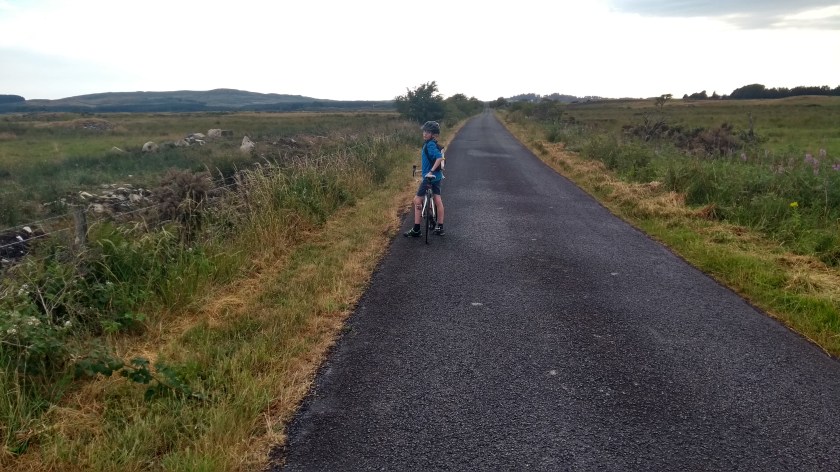
not imagine as we cycled generally west or south west through The Machars for an endless number of miles through peaceful countryside. There were very few settlements at all other than occasional farms and almost no signs of life apart from cows and sheep in the fields. It was nice but rather bleak as well and a bit of a plod as we were heading slightly uphill and straight into the rather strong wind all the way. Eventually we spotted the sea ahead and the road headed steeply downhill to Luce Bay.

IMG_20180712_184121104

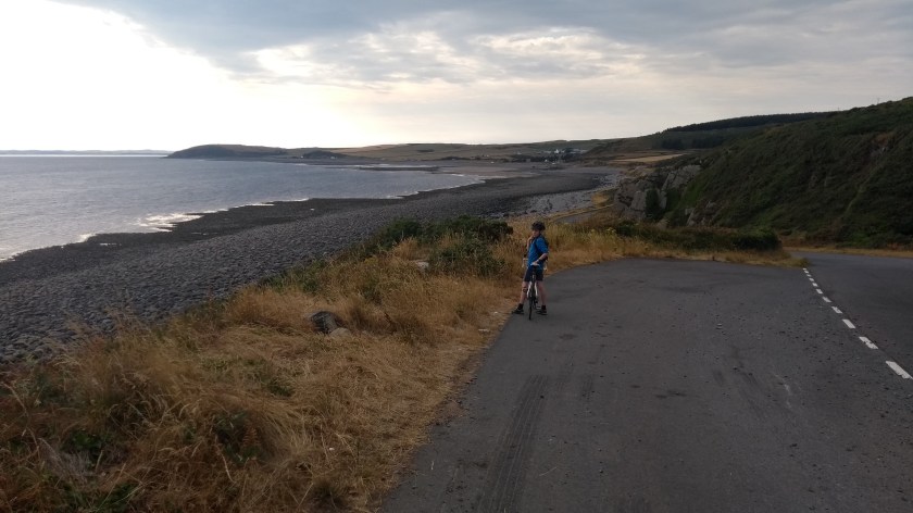
Luce Bay looked like it would be a lovely place to visit on a sunny day. There is an endless stoney beach there right next to the road and you could image that when the tide goes out, there would be miles of sand and mudflats to enjoy. Today, the wind was rather annoying so we didn’t stop this time and continued on along the A747, first along the coast and then uphill through Achenmalg which seems to be some sort of a holiday village. Soon after the village we turned left onto a narrow back road that took us straight back down to the coast again and an even prettier part of Luce Bay, before heading north for a couple of miles. At the junction we crossed over the busy A75 road to enter the town of Glenluce.

IMG_20180712_192639755

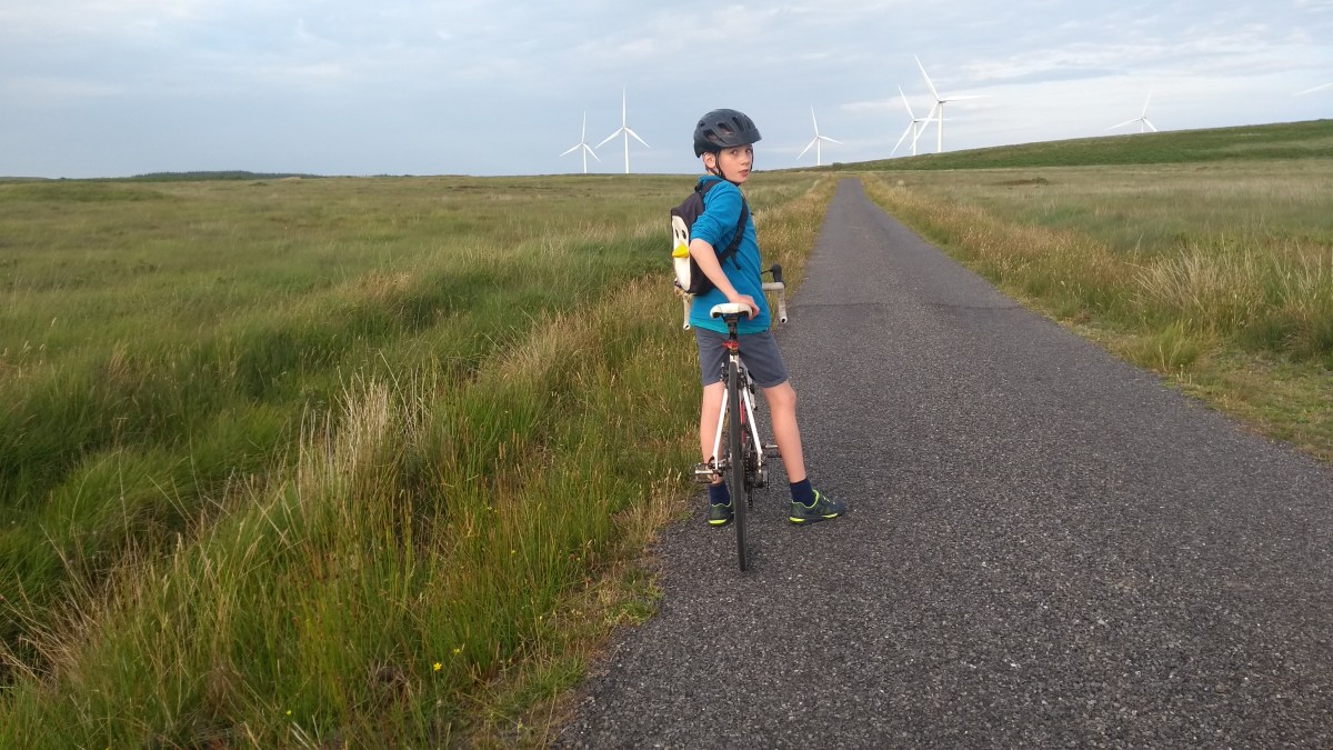
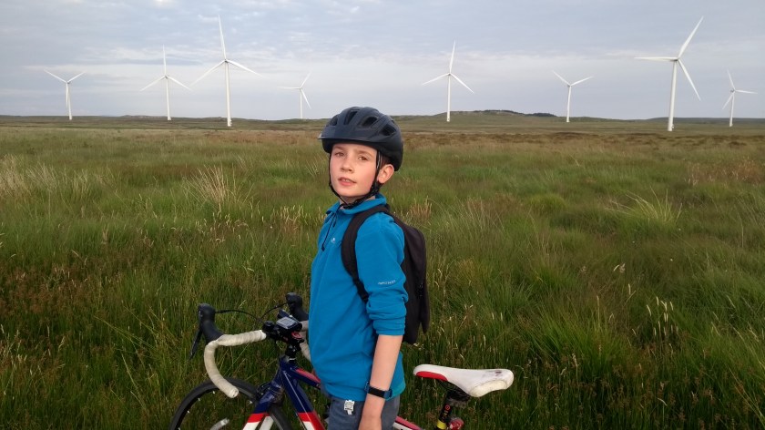
Our journey then continued north through beautiful tree covered countryside, along a lovely smooth, deserted road. It was perfect cycling conditions and the trees even gave us shelter from the wind as we passed Glenluce Abbey along the way. The road steadily climbed uphill but we hardly noticed as the gradient was shallow for most of the time and we were really enjoying this part of the ride. Soon we arrived at a village called New Luce and it was here that Dad had to consult the map to make sure we didn’t miss the turning that would take us back to Newton Stewart. We almost did miss it actually as it was one of the most narrow roads we’ve been on and Dad was slightly concerned that it would turn out to be a dead end… Thankfully it wasn’t (though after a couple of miles we did see a dead end sign straight ahead at one point, resulting in Dad panicking for a minute before realising our road was just hidden from view as it turned round to the right!) and after a steady but easy climb up to the top of an open moor, we were rewarded with some amazing close up views of a massive wind farm. The turbines seemed to go on forever as we cycled along the smooth narrow road and it almost felt as though we were cycling along the top of the world for miles and miles and miles. It was probably one of the best roads I’ve ever cycled on and will definitely be going back there.

IMG_20180712_201335052

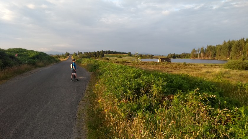
After the wind farm, the road took us gradually downhill for quite some time, in and out of the trees with the low sun shining through the branches as we passed some small lochs on the right. After a while we came to a junction with the B7027 where we turned right and rode through the edge of the Galloway Forest for a while on one of the smoothest roads I’ve ever experienced. We saw evidence of lots of forestry operations going on and there were piles of logs everywhere, but at this time of night there was nobody working and we had the road and the forest to ourselves.

IMG_20180712_203537888

Soon, we came to the A714 and sped the last few miles back down the hill to Newton Stewart. It was getting quite late (almost (9:30 pm) by the time we got back to our accommodation but it was light enough that we hadn’t even needed to put our lights on until the final couple of miles: we had beaten the setting sun with several minutes to spare! Our Glenluce loop had been an amazing circular route through hugely varied and picturesque landscapes with almost nobody else on the road. A highly recommended evening out!

Tour de Galloway day 5: Machars Meander

Route – Newton Stewart to Wigtown to Bladnoch to Kirkinner to Garlieston to Sorbie to Whauphill to Culmalzie to Newton Stewart. For route map click here.

See route on Strava.

  • Weather – dry, mainly sunny and quite warm with very little wind.
  • Bike type – road bike
  • Distance travelled – 34.59 miles
  • Riding time – 2 hours 22 minutes
  • Maximum speed – 27.7 mph
  • Average speed – 14.7 mph
  • Height climbed – 1257 feet

Because of the rubbish weather and dark evenings it has been really hard to get out cycling recently. However, this afternoon Dad and I finally managed to get out for our first cycle ride in 3 weeks. Unfortunately, it rained for most of the 3 hours we were out and it turned out to be a rather grim plod. Much less grim, however, was our summer holiday this July when the weather was lovely and it was light till late in the evening and we were able to go cycling everyday. On day 5 of our Tour de Galloway, after enjoying a nice day at the beach, we managed to get our bikes out after teatime to go for a meander through The Machars…

The Machars is the name of the peninsula to the south of Newton Stewart in Galloway and it is made up of a mainly quite flat rural landscape with picturesque little villages dotted around the coast. Our route began with a quick 6 mile blast down the minor road from Nether Barr to Wigtown which we’ve written about previously. After a short ride through the town centre we turned left onto the A714 road and sped down the slight slope at around 25 mph for the mile or so to the distillery at Bladnoch. The main road was fairly quiet but after crossing the impressive bridge over the River Bladnoch, we decided to turn left onto an even quieter back road which took us under an ancient,

IMG_20180711_181705030

overgrown railway bridge and through the middle of nowhere for a couple of miles before looping back around to the main road again. It was kind of a pointless long cut but we like long cuts and if there’s a chance to avoid a main road, we usually take it! On the A road we went left and headed south for a while on the mostly flat, fast and smooth road, passing through a couple of small villages on the way. Shortly after Kirkinner, we turned left onto the B7004. This road is the longest, straightest road I’ve ever been on and was slightly downhill all the way to the coastal village of Garlieston so we raced the 4 miles there in no time at all. Or at least it would have been quick if Dad hadn’t kept stopping to take photos along the way. I suppose it was quite a scenic ride as we passed in and out of the trees on our way to the coast. We stopped at the harbour to enjoy the views over the mud flats of Garlieston Bay bathed in evening sunshine.

IMG_20180711_184638887

After that we headed west along the B7004 again but soon turned off onto the B7052 and headed generally west again for a few miles through pretty much deserted but picturesque Machars countryside on a road that varied from amazingly smooth to terribly bumpy to anything in between. This seems to be typical of most of the roads in Galloway so it’s always wise to keep your eyes pealed so you can try to avoid the worst of the bumps and potholes…

When we reached the village of Sorbie, we turned right and headed north on the A746 for a short distance before turning back onto the B7052 again, heading generally north-west for many miles. We saw no traffic at all for what seemed like hours as we cycled through the sun-drenched countryside. In fact it seemed spookily quiet. It was as if everyone had stayed indoors to watch the England v Croatia semi-final of the World Cup which was being played that evening – when they could have been out cycling, enjoying the beautiful countryside and weather! Anyway, we eventually reached Culmalzie where we turned right briefly before heading more or less north again for a long time through a deserted landscape of endless cow fields with the Galloway hills far away in the distance.

IMG_20180711_193023244

England were already 1-0 up by the time we came to a junction with the B733 road. Here we went right for half a mile before turning left onto a very narrow road that was covered in loose chippings. It wasn’t the nicest road to cycle on but it also took us up the only real hill of the day so it was actually a pleasant change from all the easy, flat roads we’d been on for the rest of the trip. We were heading north-east for the final few miles back to Nether Barr with the late evening sun starting to set. Unfortuanely, I realised that one of my tyres had a puncture so we had to stop and Dad spent an age changing the inner tube. By this time, Croatia had equalised so we took off back down a rather steep hill towards the junction with the A714 road again. Speeding down the rather bumpy narrow road we enjoyed amazing views of the Cairnsmore of Fleet hill straight ahead, towering above the otherwise fairly flat landscape. It looks like it would be a fine hill to climb one day and probably has brilliant views from the top.

IMG_20180711_203326804

So, after a quick half mile on the main road back to our accomodation in the fading daylight, we had made it back in time to watch the extra time period of the England v Croatia match. Sadly for England, they experienced Scotland-like glorious failure as Croatia scored with 10 minutes to go to reach their first ever World Cup final…

Dad and I normally prefer slighty more challenging and hilly cycle routes but our easy meander through the Machars in the evening sunshine was very enjoyable and highly recommended.

Tour de Galloway day 1: Newton Stewart to Wigtown Loop

Route – Newton Stewart to Wigtown to Challoch to Newton Stewart. For route map click here.

See route on Strava.

  • Weather – Sunny at first, then clouding over. Warm with light winds.
  • Bike Type – Road bike
  • Distance travelled – 23.27 miles
  • Riding time – 1 hour 31 minutes
  • Maximum speed – 27.7 mph
  • Average speed – 15.3 mph
  • Height climbed – 832 feet

For our summer holidays this year we went to Dumfries and Galloway in the south-west of Scotland. We stayed in very nice self-catering accomodation at Nether Barr just outside the town of Newton Stewart and since the weather forecast looked good for the whole week, we decided to bring our bikes. There’s lots of other things to do in Dumfries and Galloway apart from riding a bike (going to the beach was my favourite activity!) but I was still determined to make sure I got out cycling everyday of the holidays, even if just for a short ride. Dad came up with the suggestion that since the Tour de France had just started, we should have our very own “Tour de Galloway”, so after tea on our first evening we headed rode off into the sunshine to begin the first stage of the Tour…

IMG_20180707_184742978

National Cycle Route no.73 goes right past Nether Barr so we followed that south all the way to Wigtown. At first you have a choice of the A714 road or a shared use path. The path looked a bit gravelly is places and the road seemed fairly quiet so we chose that for the first half mile or so. We then turned left onto a very narrow, virtually traffic-free road which took us down very close to the River Cree estuary and then the Sound of Fleet. Along the way we enjoyed great views of the impressive looking hill called Cairnsmore of Fleet on the other side of the water, as well as a view of the higher mountains in the Galloway Forest Park behind us. The road was very straight and almost completely flat so we were able to go very fast along here. However, the surface varied from nice and smooth to very bumpy with grass growing down the middle of the road. This was pretty typical of most of the roads we cycled on in the area – they were either brilliant or horrendous, with nothing in between! Anyway, after 5 or 6 flat miles we came to our first hill of the day, a rather steep but short climb which took us up into the town of Wigtown.

IMG_20180707_191000907_HDR

Wigtown is famous for being Scotland’s book town. There’s loads of nice book shops here – even all the cafes sell books too – but they were all closed for the day so we just cycled through the town centre and then out into the countryside again on the B733 road. This road was very quiet, was mainly quite flat with just a few short ups and downs and took us past countless fields of cows (there seem to be cows everywhere down here!). After a while, we came to a sign for Newton Stewart and followed it, turning right onto a very narrow back road which took us through some rather remote land (and more cow fields), climbing relatively high up at first and then gradually descending down the other side of the small hill. The views to the hills in the north were very nice as we sped down the hill. This road had been covered in loose chippings not to long ago so although it wasn’t bumpy, it wasn’t really the nicest road to cycle on with a road bike.

IMG_20180707_200249179

Before too long we reached a junction with the busiest main road in the area, the A75. We could have turned right and taken the main road a mile or so back to our accomodation. But we like a long cut so we crossed straight over onto what Google Maps says is an old military road. The road surface was certainly old and worn out with very poorly filled in pot holes all along the way. The line of grass along the middle was at times wider than the remaining tarmac! This road was long and straight and totally flat (apart from the bumps…) and it seemed like the road to nowhere as there’s no places along the way, just trees and fields and millions of rabbits. At one point we began to wonder if the road would ever end. Eventually it did though and we turned right onto the B7027, speeding down the hill for the short distance until we joined the A714 once more. This road took us mostly downhill the last mile or so to Newton Stewart. It was especially fast just as we entered the town and speed sensor warned us that we were going 30 mph. Then we had an unexpectedly steep hill to climb through the town centre before heading back out of the town. At the outskirts we had to cross the roundabout on the A75 road which we could have passed through much earlier if we hadn’t taken the long, wacky, bumpy back road. A long, wacky, bumpy back road way is always much more enjoyable than a mile of a busy road though – don’t you agree?

So after one last little sprint south along the A714, we arrived back at Nether Barr. Our first impressions of Galloway is that it’s a lot less hilly than Midlothian and the Borders but it was still a very pleasant, extremely quiet and scenic place to place to cycle. Once the bikes were packed away, I immediately got out my map to start planning the route for day 2 of the Tour de Galloway…