Gorebridge to North Berwick

Route out – Gorebridge to Crichton to Humbie to Longnewton to Garvald to East Linton to North Berwick. For route map click here.

Route back – 2 Scotrail trains (North Berwick to Edinburgh then Edinburgh to Gorebridge).

  • Weather – dry and mainly sunny, quite warm but rather windy.
  • Bike type – road bike
  • Distance travelled – 47.3 miles
  • Riding time – 3 hours 36 minutes
  • Maximum speed – 72.5 mph (not sure how that happened as it was a more believable 31.8 mph just before North Berwick…)
  • Average speed – 13.1 mph
  • Height climbed – 2064 feet

A few weeks ago we went on the train for a day out in North Berwick on the East Lothian coast. That day we climbed the Law Hill, went crab catching at the beach and had an ice cream. On the way home, the train conductor didn’t bother to check our tickets. Dad noticed that the return tickets were valid until the end of the month so we decided there was nothing to stop us using them a second time. Of course we’d need to find some way to get to North Berwick first…

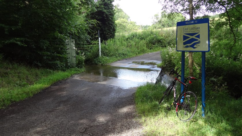
So last Sunday, Dad and I left the house at around 8:30am on our new road bikes (so much faster than my old mountain bike!) with our train tickets in our pockets and headed for North Berwick again. We began by cycling along some of my favourite quiet Midlothian back roads, including the steep hill near Crichton. The roads are mostly very good smooth surfaces around here and there’s lots of nice scenery and wildlife to see. At one point a blackbird decided to fly right through the frame of Dad’s bike when he was travelling at over 20 mph! We stopped at a ford in the road at the border with East Lothian for our first snack of the day (banana for me and apple for Dad). This was about 9 miles in to the ride and we’d still seen no traffic at all.

DSC06596

Soon after, we were on the B6371 heading for Humbie when a car finally drove past. I spotted some wild raspberries so we stopped to stuff our faces as another car and a whole load of cyclists sped by. At the junction in Humbie we turned left onto the B6368, crossing a river and up a very steep hill until the Lammermuir Hills appeared in the distance on the right hand side. This a great cycling road as it has a nice surface and lots of straight bits and interesting humps and hollows but we didn’t stay on it for long today as we turned onto a narrow road on the right, heading towards the hills. East Lothian has lots of amazing ancient road signs dotted around the countryside (with distances give to the nearest 1/8 of a mile!), and it was at one of these that Dad made a wrong turning and we ended up back at the B6368 by mistake. Rather than go back, we turned right onto this road again and then took the next proper road on the right to head uphill and into the middle of nowhere once again. At the top of the hill we got a great view of the Lammermuirs on one side and Traprain Law and North Berwick Law miles away in the distance.

DSC06620

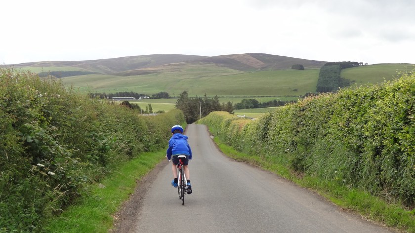
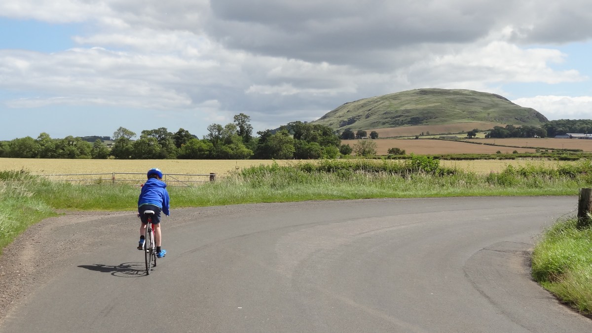
The next while was spent in some very remote parts of the region, going up and down a lot, skirting along the edge of the hills. When you think of East Lothian you think of the coast and beaches and golf courses and tourists and this area really felt a million miles removed from that. It was fantastic cycling territory though and we saw loads of road cyclists when we were there and basically no cars. At one point Dad also saw a ferret scuttling across the road in front of us but I missed it… The only real village we passed through was Garvald and after that we had to climb a mammoth hill at Papple before we finally started to get some good views over to the East Lothian coast with the impressive Traprain Law not far away now. We took a rather round-about route which took us up quite high and then down a long fast hill before going right round to the other side of the Law, where we joined up with Cycle Route 76. This took us onto a tiny road past the ruined Hailes Castle where we stopped for lunch of oatcakes with crab and cheese. Tasty. Note that this road may be very narrow but does have a fair amount of cars using it to get to the castle so be careful. After that, it was mostly downhill to the picturesque village of East Linton where we stopped in to say hello to my cousins Ella and Angus. Oh, and to eat their biscuits and use their toilet too…

DSC06660

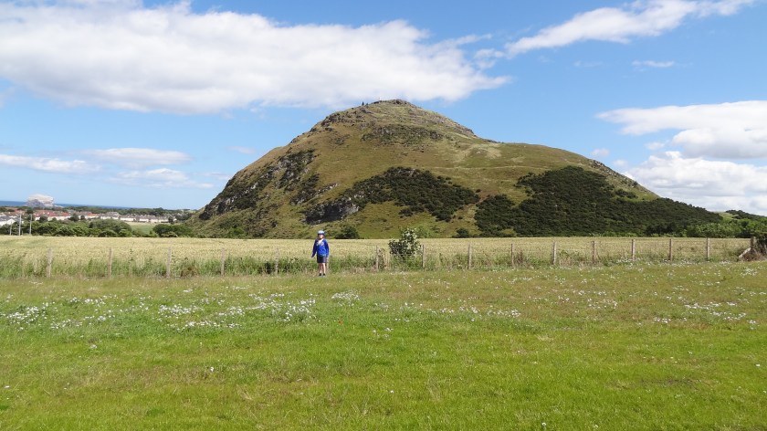
In East Linton, dad spotted an incredibly stupid signpost which pointed to North Berwick in two completely different directions. We chose left and headed uphill on the B1377 for a short distance before turning left onto the first road we came to. This quiet road gave nice views to the west and after a couple of miles of pleasant cycling, we came to the junction with the B1347 which took us past the Museum of Flight. Immediately we noticed that this road was very very busy. It might have been because it was a sunday and the weather was nice but it wasn’t much fun to cycle on. It’s also mainly uphill and there’s a lot of bad corners on it (some right angled bends too) which make it hard for cars to overtake safely. We witnessed some rather dangerous overtaking today by an idiot in a BMW. Thankfully the driver failed to kill himself or anybody else… If we ever come this way again, we’ll certainly try and find a quieter road from East Linton to North Berwick. Eventually, we got to the top of the long, gradual hill and got some stunning views of North Berwick Law with the Bass Rock in the distance.

DSC06675

Dad actually spent too long taking photos that we got to the train station 1 minute after the train had left! That left us with  an hour to kill before the next train so we cycled down the hill into the town centre and bought come ice creams… The train journey back to Edinburgh was rather interesting as there were only 2 bike spaces but at least 12 bikes managed to cram their way into the carriages. Luckily the ticket conductor didn’t seem to be too bothered and everyone made it back to Edinburgh OK. We’d made it this far without having our tickets checked again so we were already planning an alternative route to North Berwick to re-use the tickets once more. Most annoyingly though, on the train back to Gorebridge, this conductor actually bothered to check our tickets, so those plans have had to be postponed – for now.

Foraging in Midlothian

Route out – Gorebridge to Mayfield to Whitehill to Dalkeith to Eskbank to Bonnyrigg. For route map click here.

Route back – Bonnyrigg to Dalhousie to Carrington to North Middleton to Borthwick to Gorebridge. For route map click here.

  • Weather – mainly cool and cloudy with some brightness and not much wind.
  • Distance travelled – 22.53 miles
  • Riding time – 2 hours 10 minutes
  • Maximum speed – 33.4 mph
  • Average speed – 10.3 mph
  • Height climbed – 1663 feet

It is wild raspberry season at the moment so for our latest cycle run, I decided to take Dad on a rather up and down and winding route past most of my favourite local foraging spots. And I certainly filled my face along the way…

We had an early lunch of scrambled eggs and smoked salmon and then headed out of Gorebridge along Stobhill Road and then turned right onto the Crawlees Road which took us the mile or so to Mayfield. As I’ve mentioned before, Crawlees Road is to be avoided during the week because it is always very busy with lorries and vans using the industrial estate. However, at the weekend it is very pleasant to cycle on, with a smooth surface and because it is quite high up, you get brilliant views of Edinburgh, the Pentland Hills and most of Midlothian down below. At the junction, we turned right onto the B6982 into Mayfield. It’s not the most scenic place in the world – it’s basically one giant housing estate – but we cycled through the residential streets which took us steeply uphill until we eventually emerged from the houses and onto a narrow road which took us into the countryside and to a tiny place called D’Arcy at the top of the hill. It was here that we spotted an interesting signpost where the signs appeared to indicate that it was 2 miles and slightly downhill to Edgehead or 3 miles and much more downhill to Dalkeith. We chose Dalkeith and it was great fun free-wheeling at around 30 mph all the way to there in only a few minutes. We passed through the village of Whitehill on the way and briefly enjoyed the amazing view over Edinburgh and across the water to Fife as we sped through.

In Dalkeith we passed through some more residential streets and then joined the cycle path of cycle route no.1 which we have written about lots of times before. The path is very nice to cycle on and takes you through the Newbattle Estate and past the golf course. Most importantly though, there are millions of wild raspberries to eat along the way – including lots of delicious yellow ones. We had to keep stopping every few yards to stuff our faces so this really slowed down our average speed today. Oh well…

We basically followed route no.1 cycle path for a while after that, passing through Eskbank station (where we saw a train) and then into Bonnyrigg (more foraging along the way). At Bonnyrigg, we headed off the path but stayed with route no.1 and turned left onto the B704 in the direction of home – but we weren’t going home just yet. At the crossroads next to a church, route no.1 turns right in the direction of Carrington. We were going there but decided to take a long cut so headed straight on up the hill to Dalhousie Castle. We stopped near the castle, just before the bridge with traffic lights, to forage once again at another large patch of raspberries at the roadside. From here Dad got a great photo of Newtongrange with the old coal mine (now the mining museum) in the background. Then we crossed the bridge at the green light and headed uphill for a short distance. Just before the Lothian Cat Rescue place on the right, we turned off the road and onto a path that we know. It’s rather narrow at first and very overgrown but we managed to cycle on it reasonably OK as we passed fields of sheep and cows. The track ended at a gate which we discovered was padlocked. It tried to lift my bike over but it was too hard so Dad had to do it. It was rather annoying and given that the path is actually a signposted walking route, we thought it was rather strange that the gate was locked. Anyway, back on tarmac again, we turned right and headed down the quiet, narrow road into Gore Glen and then steeply back up the other side, passing the fields and trees that make up some of the nicest parts of Midlothian. At Carrington Barns Farm, we turned right onto a very narrow and very bumpy road, lined with trees on both sides and after half a mile or so we came to a junction with a much smoother road where we turned left, back onto cycle route no.1 once more.

We soon passed through Carrington Village and then sped along the quiet and smooth road for a mile or 2 to the junction with the B6372. We turned left here following the route no.1 signs again, soon turning off the main road onto another narrow back road which took us up a short but steep hill to Castleton farm. At the farm, we turned left onto the quietest road in the world. We cycle on it quite often but I can’t remember having ever seen a car on it and only 1 other bike. We like to call it our secret road. Anyway, it heads gradually uphill for a quite a long time. You get some of the best views along the way over to the Pentland Hills, Edinburgh and even Gorebridge! (Gorebridge even looks nice from a distance…) At the top of the hill you can even see North Berwick Law which is probably over 30 miles away in East Lothian. We then sped down the other side of the hill as fast as we could, trying not to crash at all the sharp corners. We managed thankfully. Then we turned right and soon after (just before the Limeworks) turned left into the village of North Middleton (via a handy underpass which allows you to avoid crossing over the busy A7 road). We scooted our way over the North Middleton speed bumps and out of the village on the quiet narrow road and down the steep hill to Borthwick, enjoying the views of the castle and the Borders Railway along the way. After that we had a killer climb up the other side, probably 2 miles of constant steepness. Dad couldn’t keep up with me! Eventually, at the top of the hill, just half a mile or so from home, we got amazing views of Gorebridge, the Pentland and Moorfoot Hills so all the hard work was worth it. From there it was then another simple free-wheel the rest of the way home.

It may have been only 22 miles but that route climbed over 1600 feet which really does prove just how hilly Midlothian really is. Oh, and if you like wild raspberries, Midlothian is also a great place to visit in summer…