Foraging in Midlothian

Route out – Gorebridge to Mayfield to Whitehill to Dalkeith to Eskbank to Bonnyrigg. For route map click here.

Route back – Bonnyrigg to Dalhousie to Carrington to North Middleton to Borthwick to Gorebridge. For route map click here.

  • Weather – mainly cool and cloudy with some brightness and not much wind.
  • Distance travelled – 22.53 miles
  • Riding time – 2 hours 10 minutes
  • Maximum speed – 33.4 mph
  • Average speed – 10.3 mph
  • Height climbed – 1663 feet

It is wild raspberry season at the moment so for our latest cycle run, I decided to take Dad on a rather up and down and winding route past most of my favourite local foraging spots. And I certainly filled my face along the way…

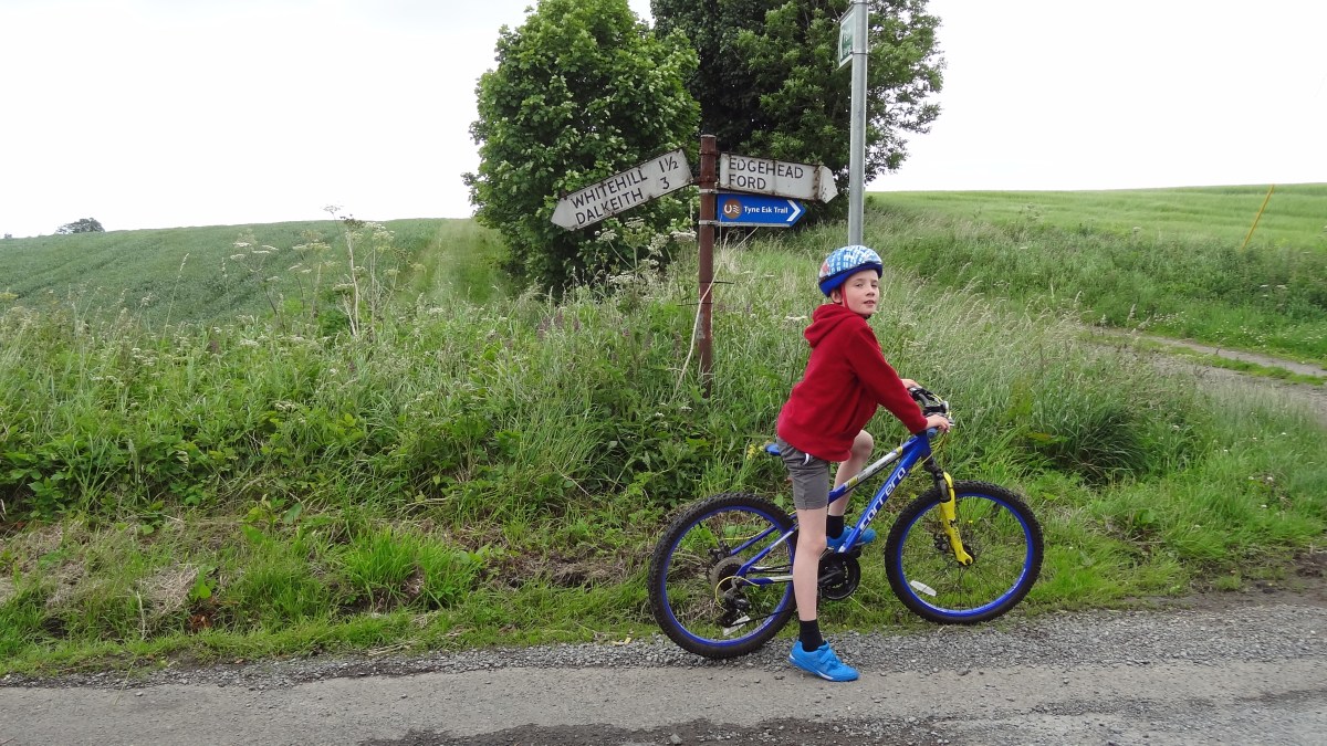
We had an early lunch of scrambled eggs and smoked salmon and then headed out of Gorebridge along Stobhill Road and then turned right onto the Crawlees Road which took us the mile or so to Mayfield. As I’ve mentioned before, Crawlees Road is to be avoided during the week because it is always very busy with lorries and vans using the industrial estate. However, at the weekend it is very pleasant to cycle on, with a smooth surface and because it is quite high up, you get brilliant views of Edinburgh, the Pentland Hills and most of Midlothian down below. At the junction, we turned right onto the B6982 into Mayfield. It’s not the most scenic place in the world – it’s basically one giant housing estate – but we cycled through the residential streets which took us steeply uphill until we eventually emerged from the houses and onto a narrow road which took us into the countryside and to a tiny place called D’Arcy at the top of the hill. It was here that we spotted an interesting signpost where the signs appeared to indicate that it was 2 miles and slightly downhill to Edgehead or 3 miles and much more downhill to Dalkeith. We chose Dalkeith and it was great fun free-wheeling at around 30 mph all the way to there in only a few minutes. We passed through the village of Whitehill on the way and briefly enjoyed the amazing view over Edinburgh and across the water to Fife as we sped through.

In Dalkeith we passed through some more residential streets and then joined the cycle path of cycle route no.1 which we have written about lots of times before. The path is very nice to cycle on and takes you through the Newbattle Estate and past the golf course. Most importantly though, there are millions of wild raspberries to eat along the way – including lots of delicious yellow ones. We had to keep stopping every few yards to stuff our faces so this really slowed down our average speed today. Oh well…

We basically followed route no.1 cycle path for a while after that, passing through Eskbank station (where we saw a train) and then into Bonnyrigg (more foraging along the way). At Bonnyrigg, we headed off the path but stayed with route no.1 and turned left onto the B704 in the direction of home – but we weren’t going home just yet. At the crossroads next to a church, route no.1 turns right in the direction of Carrington. We were going there but decided to take a long cut so headed straight on up the hill to Dalhousie Castle. We stopped near the castle, just before the bridge with traffic lights, to forage once again at another large patch of raspberries at the roadside. From here Dad got a great photo of Newtongrange with the old coal mine (now the mining museum) in the background. Then we crossed the bridge at the green light and headed uphill for a short distance. Just before the Lothian Cat Rescue place on the right, we turned off the road and onto a path that we know. It’s rather narrow at first and very overgrown but we managed to cycle on it reasonably OK as we passed fields of sheep and cows. The track ended at a gate which we discovered was padlocked. It tried to lift my bike over but it was too hard so Dad had to do it. It was rather annoying and given that the path is actually a signposted walking route, we thought it was rather strange that the gate was locked. Anyway, back on tarmac again, we turned right and headed down the quiet, narrow road into Gore Glen and then steeply back up the other side, passing the fields and trees that make up some of the nicest parts of Midlothian. At Carrington Barns Farm, we turned right onto a very narrow and very bumpy road, lined with trees on both sides and after half a mile or so we came to a junction with a much smoother road where we turned left, back onto cycle route no.1 once more.

We soon passed through Carrington Village and then sped along the quiet and smooth road for a mile or 2 to the junction with the B6372. We turned left here following the route no.1 signs again, soon turning off the main road onto another narrow back road which took us up a short but steep hill to Castleton farm. At the farm, we turned left onto the quietest road in the world. We cycle on it quite often but I can’t remember having ever seen a car on it and only 1 other bike. We like to call it our secret road. Anyway, it heads gradually uphill for a quite a long time. You get some of the best views along the way over to the Pentland Hills, Edinburgh and even Gorebridge! (Gorebridge even looks nice from a distance…) At the top of the hill you can even see North Berwick Law which is probably over 30 miles away in East Lothian. We then sped down the other side of the hill as fast as we could, trying not to crash at all the sharp corners. We managed thankfully. Then we turned right and soon after (just before the Limeworks) turned left into the village of North Middleton (via a handy underpass which allows you to avoid crossing over the busy A7 road). We scooted our way over the North Middleton speed bumps and out of the village on the quiet narrow road and down the steep hill to Borthwick, enjoying the views of the castle and the Borders Railway along the way. After that we had a killer climb up the other side, probably 2 miles of constant steepness. Dad couldn’t keep up with me! Eventually, at the top of the hill, just half a mile or so from home, we got amazing views of Gorebridge, the Pentland and Moorfoot Hills so all the hard work was worth it. From there it was then another simple free-wheel the rest of the way home.

It may have been only 22 miles but that route climbed over 1600 feet which really does prove just how hilly Midlothian really is. Oh, and if you like wild raspberries, Midlothian is also a great place to visit in summer…

Gorebridge to Dalkeith the Long Way

Route out – Gorebridge to Dalhousie to Capielaw to Rosewell to Bonnyrigg to Eskbank to Dalkeith. For route map click here. Note that Google Maps doesn’t seem to know about all of the cycle routes through Dalkeith (no.196 and no.1). After Bonnyrigg, just follow the all the blue signs and this takes you mainly off road via Eskbank Station and Newbattle Golf Course until Dalkeith Campus.

Route back – Dalkeith to Crossgatehall to Cousland to Fordel Mains Farm to d’Arcy to Gorebridge. For route map click here.

  • Weather – sunny and cloudy, quite warm and very windy.
  • Distance travelled – 23.32 miles
  • Riding time – 2 hours 30 minutes
  • Maximum speed – 37.5 mph
  • Average speed – 9.3 mph

Today, Dad and I decided to go the long way to Dalkeith so that we could investigate one of the few sections of cycle route no.196 that we hadn’t already been on from Hardengreen Tesco to Crossgatehall. It was a lovely part of the route and I really enjoyed it.

Our route began from our house in Gorebridge as usual. We sped out of the village down the steep B704 at over 30mph (breaking the speed limit but not by more than 10% so I’m sure we won’t get a speeding ticket!). We stopped for a quick photo of Dalhousie Castle and then soon turned left onto cycle route no.1, heading for Carrington. After a mile or so we turned right onto a very quiet minor road and it was getting hot so I took off my fleece. About 10 seconds later a wasp flew in and decided to sting me on the arm – it was really sore! Believe or not, I was stung yesterday as well. How annoying… We then turned off this road onto a very bumpy single track road to Capielaw. This turned into a rather muddy track after a while, taking us around the back of Whitehill House Golf Course which looked rather nice. Eventually, the mud and potholes turned into proper road again and we sped the last mile downhill to Rosewell.

At Rosewell we joined the cycle path of route no.196 and zoomed downhill all the way through Bonnyrigg to Tesco, stopping just twice to forage for wild raspberries. From here there’s a new section of cycle path which goes through Eskbank Station. Sadly, we didn’t see any trains today. After the station, we must have missed the cycle route sign and cycled the wrong way for a few hundred yards before realising our mistake and turning round. The route no.196 signs appear to suggest cycling round Eskbank Toll roundabout but we thought it looked far too busy and dangerous so we took a short cut through The Justinlees car park instead. The next part of the route was my favourite, going through the woods alongside Newbattle Golf Course where we stopped on a bridge over the River Esk for a drink. From there it was all downhill along the cycle path and some sections of pavement until we reached a junction in the cycle route next to lots of electricity pylons, just before Whitecraig. We turned right and followed the sign for route no.196 until we reached the traffic lights at Crossgatehall.

After a short downhill section on the relatively quiet A6124, we then turned left and headed steeply uphill to the village of Cousland where we stopped for a quick oatcake and drink. In Cousland we spotted something we hadn’t seen before – some old narrow gauge railway trucks from the Cousland Lime Works. After Cousland we cycled uphill again until Fordel Mains Farm and then uphill once more to d’Arcy which was the highest point on the route and gave us a great view over to North Berwick Law, the Bass Rock, Traprain Law and the Lammermuir Hills. A few weeks ago we had come this way so that we could speed down a really steep section here. We broke our fastest ever speeds that day and today we completely smashed the records again. I reached 37.5mph and Dad even got to 41.9mph! It was really amazing going that fast. We then went along at a more reasonable speed for the last few miles home.

Gorebridge to Penicuik Circular Route

Route out – Gorebridge to Bonnyrigg to Rosewell to Roslin Glen to Penicuik. For route map click here. Google Maps says to go onto the A6094 for a short section before Rosewell but you don’t need to do this – just follow the path of Cycle Route 196 instead.

Route back – Penicuik to Mount Lothian Farm to Edgelaw Reservoir to Carrington to Gore Glen to Gorebridge. For route map click here.

  • Weather – mostly cloudy, cold at first but warm later, some bright spells and no wind.
  • Distance travelled – 22.18 miles
  • Riding time – 2 hours 9 minutes
  • Maximum speed – 32.8 mph
  • Average speed – 10.3 mph

On Sunday morning we got up early and by 7am we were already on our way to Penicuik, which is near the Pentland Hills about 10 miles from our house. I had been thinking of cycling there for a while and there are lots of different ways to get there. Today, we decided to go there along the Dalkeith to Penicuik Walkway which follows the route of the old railway line.

To save time, we headed straight out of Gorebridge along the main B704 road. At this time of the day on a Sunday traffic is really quiet, but I wouldn’t recommend cycling on it normally. This road heads steeply downhill and me and Dad both reached 30mph before we reached the traffic lights at the crossroads with the A7. We went straight through the lights and headed downhill again passed Dalhousie Castle where we stopped for a quick photo. Soon we reached the town of Bonnyrigg which is about 3 miles from Gorebridge and just before the town centre, we turned left onto Cycle Route no.196 which follows the Dalkeith to Penicuik Walkway. Straight away we saw evidence of the old railway with the disused Bonnyrigg station platform. At this point the cycle path is a nice smooth surface and quite flat. The only real hazard is that you have to make sure you don’t cycle through dog poo – there is a lot of of it on this section of the route. Dad also discovered that you have to watch out for the wildlife too – he accidentally ran over a massive slug and it splattered all over his knee!

The next village along the line is Rosewell and here I spotted a no.49 double decker bus heading into the village. We stopped here for our first snack of the day: I had an apple and Dad had a banana. After Rosewell, the path becomes much more bumpy and muddy in places as you head into the picturesque Roslin Glen. We didn’t see any dog poo on this section of the path but there was a lot of horse poo to avoid instead… We passed another old station platform and cycled under and over some bridges and through 2 old railway tunnels before we eventually arrived in Penicuik.

Penicuik is a bit bigger and has more shops than Gorebridge but we didn’t go into the town centre,  just stopping for a few minutes to have our crisps. We then turned onto the B6372 and cycled up the really steep hill out of the town and into the countryside. The road was very quiet apart from lots of other cyclists and we stopped for a few photos along the way, including one at Mount Lothian Farm. This road is quite high up and in the winter you get a lot of snow here but today it was far too hot for snow… After a few miles, we took a turning off the road and followed a track through the trees and down to Edgelaw Reservoir. On the way, we spotted a deer and at the reservoir we spotted lots of people fishing. We didn’t spot any fish though.

After the reservoir we left the muddy track behind and went back onto a nice smooth, straight and deserted road which took us a few miles (almost all downhill) to Carrington. It was on this section that I managed to go over 30mph two more times. Dad even went over 35mph at one point. Carrington is a very quiet little village and it has some nice benches so we stopped for our last snack of the day – chocolate digestives! From Carrington, we sped downhill all the way to Gore Glen on the really quiet single track road. Just before the glen, I reached my world record fastest speed of 32.8mph. All these downhill sections came at a price though as the road from Gore Glen back to Gorebridge is uphill all the way. It was fine though because we eaten our digestives so had lots of energy. Soon we were back home, less than 3 hours after we’d left. Amazingly our average speed was also a world record for us today at 10.3mph.