Gorebridge to North Berwick (vol. 3)

Route out – Gorebridge to Mayfield to Elphinstone to New Winton to Pencaitland to East Saltoun to Bolton to Haddington to Drem to Dirleton to North Berwick. For route map click here.

Route back – Scotrail train to Edinburgh then Borders Railway train to Gorebridge.

See route on Strava.

  • Weather – Dry, cloudy and cold but not much wind.
  • Bike type – road bike
  • Distance travelled – 32.24 miles
  • Riding time – 2 hours 45 minutes
  • Maximum speed – 29.1 mph
  • Average Speed – 11.7 mph
  • Height climbed – 1771 feet

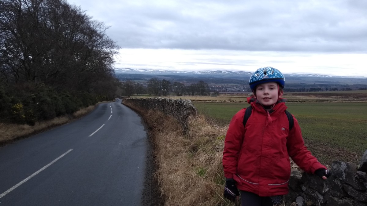
There seems to have been a lot of cold weather this winter compared to normal. I don’t mind this because we’ve been able to go out sledging and building igloos but it has been virtually impossible to get out for a decent cycle run for months now due to the snow, ice and wind chill. Amazingly, even though it was still very cold today, there wasn’t much wind at all and the roads weren’t slippy for once so Dad and I decided to venture out on our bikes.

We left the house at 9:30am and took our usual route through the houses, uphill out of Gorebridge and onto the B6372 heading east. Almost immediately we turned left onto the quiet narrow road that heads steeply up to Camp Wood. As we climbed, we got a fine view over to the snow-covered Moorfoot Hills on our left and at the top of the hill, we were able to see right over to East Lothian and the snowy Lammermuir Hills to the south. The Moorfoots and Lammermuirs always look much more impressive when covered in snow I think. From Camp Wood we sped off down the hill to Mayfield with a great view of the equally impressive and snowy Pentland Hills on our left as we free-wheeled down the smooth road.

IMG_20180218_095905699_HDR

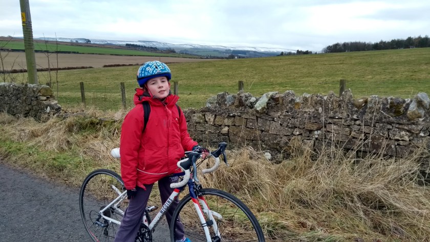
After skirting around the edge of Mayfield, we started climbing up another steep narrow road for half a mile or so until we reached the highest point of the route at d’Arcy. After cycling only 2.5 miles so far we’d already climbed 300 feet – possibly one of the hardest starts to a route ever! From d’Arcy, we turned left and cycled along the quiet high road (there was even some snow at the side in places) and we enjoyed some amazing views over to Edinburgh and the Pentland Hills once more. We then turned left at the next junction and headed north towards Whitehill for a few hundred yards before turning right onto the rather bumpy but very scenic road to Fordel Mains farm, along which you get some of the best views in Midlothian as you look down upon Edinburgh and Fife in the distance. Soon enough we were speeding down the hill along the (very quiet) A6124, out of Mid and into East Lothian where we had to stop at the traffic lights at Crossgatehall.

When the lights changed to green we turned right onto the B6414 and climbed up the gradual hill for a couple of miles to the village of Elphinstone. This road is reasonably quiet and you get some good views on your right of the Lammermuir Hills as you cycle along. Just past Elphinstone we turned right at the sign for “Research Centre” and after half a mile or so of easy riding (passing the research centre on the way – no idea what they research there though) we turned right onto another B road briefly before a quick left turn onto another narrow and flat but smooth back road which took us quickly to the B6355. This is a nice road, not too busy and it has a good surface. It’s also very scenic, with good views of the hills in front of you. We even spotted a couple of rather grand

IMG_20180218_105804230_HDR

turreted gatehouses to private Estates near Pencaitland so we stopped to have a nosey as usual. Not far after East Saltoun, we turned left onto the B6368 and sped down the hill to a nice little village called Bolton. We didn’t stop though and carried on along this road, following the River Tyne until we came to the town of Haddington.

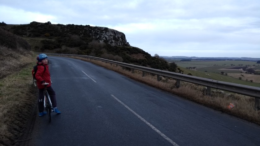
As you enter the town, there is a bridge across the river with traffic lights and it was here that I had my first ever crash. As we approached down the hill towards the bridge, the lights changed to amber and even though there would have been plenty time to get across, Dad apparently disagreed and decided to stop for some reason. I must have braked too hard and my back wheel skidded on the damp road surface and I ended up on the floor. Thankfully there was little damage to me (just a small bump to the knee) or the bike but it was a bit scary at the time. It was lucky the road was quiet and there were no cars anywhere near us at the time. So after dusting myself down and having a quick bag of crisps and an apple, we were back on the road again. We left the town as quickly as possible and took the road signposted for Camptown. This is a lovely road that takes you steeply up into the lesser known Garleton Hills. At least it should be a lovely road as it’s a nice smooth surface and you get great views behind you of the lammermuirs and then a fine view of the Firth of Forth as you descent the other side of hill. Unfortunately, far too many cars seem to use this road (probably as a short cut) and many of them drive far too fast and overtake when it’s not safe to do so. So take care if you decide to cycle this way.

IMG_20180218_123232588

In fact, taking care is the main piece of advice for the last 8 miles of the route from here to North Berwick. We’ve tried out a few routes to North Berwick now and each time, the section from the Haddington area northwards has been entirely unpleasant. Even though the roads are only B class, do not be fooled by this. They are very busy (busier than most A roads in Midlothian), have lots of bad corners and there are a lot of bad drivers out there. At one point just before Drem, a white van decided to overtake us even though there was a car coming the other way. Shortly after that we observed the worst piece of driving ever on the B1345 near Fenton Barns when an impatient driver decided he could wait no longer to get past so he decided use a layby on the left to undertake us! Dad couldn’t believe it and indicated this to the driver by holding up one of his fingers…

Thankfully, the rest of the journey was less eventful but was completely spoiled by the heavy traffic. We were glad to turn off briefly into the peaceful village of Dirleton and then onto the shared use cycle path next to main road that took us to our destination. After all that, we decided to go for a well deserved ice cream before getting the train home. As much as I like East Lothian, I think we’ll be sticking to the much quieter and more pleasant southern and western parts of the region from now on.

Gorebridge to Blackhope Scar (nearly…)

Route out – Gorebridge to Fushiebridge to Middleton to Gladhouse Reservoir to Moorfoot to Moorfoot Hills. For route map click here.

Route back – Moorfoot Hills to Moorfoot to Carrington to Gore Glen to Gorebridge. For route map click here.

  • Weather – mainly sunny and very warm but cloudy in the hills. Very little wind.
  • Distance travelled – 24.05 miles
  • Riding time – 2 hours 13 minutes
  • Maximum speed – 32.7 mph
  • Average speed – 10.7 mph
  • Height climbed – 1099 feet

Saturday was Gorebridge gala day. It’s a great day out if you enjoy bagpipes, junk food, expensive rides and even more expensive bouncy castles, surrounded by hundreds of noisy drunk people and screaming kids… It’s actually really not that bad but this year Dad and I decided to give it a miss because the weather was nice, so we went cycling instead. My sister Isla (who is only 7 years old) came with us too. It turned out to be her longest ever bike ride. It also turned out to be a bit of an adventure so read on…

After an early lunch of boiled eggs and soldiers, we took a familiar route out of Gorebridge along Vogrie Road and out into the Midlothian countryside. The narrow road took us through some Beech trees, high up above the Borders Railway line and soon we were at the lovely place called Fushiebridge where we stopped to look for trains as we crossed over the bridge to the other side of the train track. Sadly no trains to be seen today. We then sped down the hill until reached the junction with the main A7 road where we saw our first cars of the day. Rather than cycle on the busy road, we turned left and took the pavement along the side and cycled for a few hundred yards until we reached the Midlothian Council gritter depot. At that point we (very safely) pushed our bikes across the A7 and took another very quiet, narrow and very smooth road for about a mile or so (passing the Middleton Limeworks and climbing a massive hill) before we came to the crossroads at Middleton where we stopped for our first snack of the day (apple, orange and banana for me, Isla and dad). From Middleton, we got an amazing view back through the trees to Gorebridge which looked surprisingly nice in the sunshine with Arthur’s Seat in the background.

Next we followed the signpost for Bonnyrigg and cycled around the back of the limeworks quarries. You get some of the best views of the Pentland Hills, Edinburgh and even East Lothian along this road as it’s very high up. It’s also almost traffic-free but it is part of Cycle Route no.1 so you normally see lots of cyclists. Not today though strangely enough, despite the good weather. We turned left at the next proper junction, speeding past Outerston Farm and fields of sheep as we headed in the direction of the Mootfoot Hills. At the end of this road, we turned left again and up a steep hill and a mile or so of deserted back road later, we had arrived at Gladhouse Reservoir which looked nice in the sunshine with the Moorfoot Hills behind it. We stopped here for another snack (Yorkie buttons for Isla and oatcakes for me and dad) before heading along the smooth, mainly flat narrow road around the side of the reservoir.

After a few minutes we reached a junction and turned left onto another quiet and equally smooth road for only a few hundred yards before turning left at the sign for Moorfoot. Straightaway, we got an amazing view of the Moorfoot Hills as we cycled the half mile or so to Moorfoot Farm where the proper road ended. There, we followed a bumpy track, climbing gradually as we went, passing the ruins of Hirendean Castle and following a stream (which was actually the River South Esk) further and further into the hills. We’d never been along here before so weren’t sure what to expect and it was really quite hard to cycle on but we managed reasonably well. Even Isla didn’t complain too much… Eventually, with Bowbeat wind farm not too far ahead on top of the hill and just before reaching a small hut, the path forked in two. Dad checked the map and worked out that the left path would eventually take us to the top of the hill and to the highest point in the area called Blackhope Scar (651m high) which lies right on the border between Midlothian and the Borders. I’d always wanted to go there so we went that way. It was far too steep and bumpy to cycle on though so we left the bikes (and helmets) and decided to take a walk up to the top of the hill. It was a short and easy walk to the top and we got an amazing view of the wind farm as the sun came out from the clouds. Unfortunately, the path ran out about 100m below (and probably 20 minutes from) the summit and the grassy ground was very squelchy and boggy and we didn’t have walking boots on, so we decided (or rather Dad decided) it wasn’t worth getting wet feet for the sake of getting to the very top. So we headed back down the bumpy path to our bikes and we sped downhill along the bumpy track back to Moorfoot.

Leaving the hills and the Moorfoot road behind, we turned right and headed uphill on the quiet road until the junction with the B6372. We turned right and cycled for a mile or 2 along a very straight road, mostly downhill and with loads up humps and hollows to make it fun. Just outside Temple, we turned left and followed another quiet road for a mile or so to the village of Carrington where we turned right onto the very narrow back road to Gore Glen. This road is all downhill for about 2 miles and is great fun to cycle on. Just watch out you don’t go too fast down the very steep section just before the Glen as there’s a sharp bend at the bottom of the hill and it would be easy to end up in the trees… Then there was another steep hill to get up from the Glen and back to the junction with the A7 main road. From there we turned left and headed up one last hill into Gorebridge through the new housing estate and then Arniston Park before heading home. It wasn’t the longest cycle route in the world (though it actually was a world record for Isla!) but it was certainly one of the most interesting, most scenic and most enjoyable.

Grand Tour of the Moorfoot Hills

Route Out – Gorebridge to Crichton to Tynehead to Fala Dam to Fala to Heriot to Pirntaton Farm. For route map click here.

Route Back – Pirntaton Farm to Over Shiels Farm to George Wood to Ladyside Farm to Middleton to Gorebridge. For route map click here.

A large part of this route is off road through Fala Moor and the Moorfoot Hills so make sure you remember to take a map with you so you don’t get lost. See images below for the maps we took with us.

  • Weather – Sunny and cloudy, light winds and quite warm.
  • Distance Travelled – 38.69 miles
  • Riding Time – 4 hours 31 minutes
  • Maximum Speed – 30.1 mph
  • Average Speed – 8.5 mph

The weather brightened up on Saturday afternoon, so after lunch Dad took me on an amazing cycle route through the Moorfoot Hills that he’d discovered a while ago. He told me it would be really scenic but also extremely steep in places so would be very hard. He was right…

The first part of the route is basically the same as the Gorebridge to Fala Dam route that we went on a few weeks ago. We varied it slightly by staying on the B6367 all the way from Crichton to Tynehead. This is a nice quiet road with good views of the Pentland and Moorfoot Hills but it also felt a lot steeper than it looked for most of the way. At Tynehead we turned left onto the B6458. I thought this road looked completely flat but it must have been slightly downhill and we fairly zoomed the few miles to the junction with the main A68 road at almost an average of 20mph. Then, after crossing over the A68 onto a single track road (where we saw some rather unusual looking goats), we sped downhill to Fala Dam (where we once again met up with the nice old dog that we saw the last time we stopped there). After Fala Dam there’s a really steep uphill section for about a mile until the village of Fala. Here, we stopped for a rest and some crisps in the play park before tackling one of the hardest sections of the route – the Fala Moor Road.

About 50 yards outside Fala, you need to cross over the busy A68 road to get onto the Fala Moor Road. It’s not really a road (Dad says it maybe used to be a long time ago) and it’s very bumpy and covered with loose stones making the relatively gentle slope really hard to cycle on – not at all suitable for road bikes. It was a bit of a slog really, but at least we saw 2 deer on the way up. Once at the top, the “road” becomes a bit less bumpy (thankfully) and levels out at around 300m high for a couple of miles through the moor and we got some nice views of the hills and some wind farms in the distance. The “road” ends suddenly at a sharp right turn and becomes a track through sheep and cow fields. Thanks to the recent rain and the cows, the track either side of the several gates along the way had turned into a muddy swamp which was impossible to cycle through. It was a bit of a relief to eventually reach Brothershiels Farm where we rejoined a proper tarmac road once more for the last mile until the junction with the main A7 road.

We only went on the main road for a few hundred yards but annoyingly, this was the bumpiest road surface of the day so if you are cycling on this part of the A7, please be careful and don’t go too fast in case you come a cropper… We soon turned off the main road and went under the under-pass to the other side of the Borders Railway line into the village of Heriot. After that we basically followed the railway line southwards on the Old Stage Road. This is a lovely, quiet single track road which has lots of up and downhill sections and lots of good views too (and lots of foraging opportunities!). After a few miles we reached the turning on the right for Pirntaton farm and the road started to go uphill. Dad had told me there would be some unbelievably good conker trees next to the farm – and he was right, I’ve never seen so may conkers before. We filled up our rucksack with as many as we could fit before carrying on up the narrow road as it became steeper and steeper the further into the hills we went. Eventually, at a height of about 350m, the road ran out, and we had a brilliant view of the Moorfoot Hills as we crossed a cattle grid onto the track which would lead us right over the hills to the other side…

This section was a lot of fun with loads of fast downhills but some incredibly steep uphills too. The views of the hills were amazing and we saw loads of wildlife – millions of grouse and pheasants, a heron, hares and buzzards. The track is a very good surface for most of the way – a bit like the kind of hard packed gravelly surface you find on some cycle paths –  and it only became too difficult to cycle on the very steepest parts where the surface was quite loose (I wouldn’t try this route on a road bike by the way…). Amazingly, we only had to push for a couple of very short sections. We had to cycle through 5 fords along the way (this is where the stream flows over the path). This was quite hard the first time but Dad told me to use a low gear and pedal as fast as possible otherwise I would get stuck – and he was right again and it wasn’t too bad at all actually. I only got my feet wet a couple of times! After a while we eventually managed to struggle our way at 2mph in gear 1 up to the highest point of the hill at around 525m. Here there is a small area of trees called George Wood where we stopped to forage for wild blueberries (very tasty). From there, the view was amazing and we could even see the Eildon Hills at Melrose far away in the distance. We also got a good view of the path we’d cycled up and could see exactly how ridiculously steep it was… The ride down the other side of the hill is basically all downhill (obviously) and is great fun. However, the first part is VERY steep so you have to be extremely careful not to go too fast or skid off the path into the heather… Soon enough, the slope becomes more gentle and we had an easy, fast decent (through the fords) the rest of the way to Ladyside Farm where we joined onto the B709.

The last part of the route follows the B7007 back to Gorebridge via Middleton and Fushiebridge. See the route Gorebridge to Dewar for more details about this section. Just before the high point in the road, we stopped at the entrance to the track to Blackhope  Farm and from there we got a good view back down the valley to the Hill that we’d cycled over the top of. It was quite a amazing to think we’d managed to do it. In total (according to Google Maps anyway) we’d cycled up nearly 3000 feet of accent over the whole afternoon which is almost as much as cycling to the top of a Ben Nevis (so Dad said anyway)! So when we got back to Gorebridge, we decided we deserved to stop at the Gorefry takeaway for a seafood pizza before heading home. It was a really amazing journey through the mountains and one I’ll certainly be going on again.